IMAGES TAKEN NEAR TO
Lynmouth Avenue, CHELMSFORD, CM2 0TR
Introduction
This page details the photographs taken nearby to Lynmouth Avenue, CM2 0TR by members of the Geograph project.
The Geograph project started in 2005 with the aim of publishing, organising and preserving representative images for every square kilometre of Great Britain, Ireland and the Isle of Man.

There are currently over 7.5m images from over14,400 individuals and you can help contribute to the project by visiting https://www.geograph.org.uk
Image Map
Images are licensed for reuse under creativecommons.org/licenses/by-sa/2.0
Notes
- Clicking on the map will re-center to the selected point.
- The higher the marker number, the further away the image location is from the centre of the postcode.
Image Listing (47 Images Found)
Images are licensed for reuse under creativecommons.org/licenses/by-sa/2.0
Image
Details
Distance
1
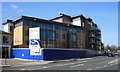
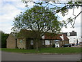
Affordable Housing
New development on the former site of a Volkswagen dealership, which has relocated to a former Marconi factory.
Image: © Paul Franks
Taken: 1 Apr 2012
0.05 miles
2
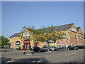
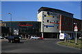
Chelmsford, superstore
Tesco Homeplus, on Parkway. http://www.tesco.com/storelocator/access/details.asp?bID=5389&l=C
Image: © Mike Faherty
Taken: 15 May 2010
0.07 miles
3
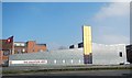
Salvation Army Citadel
Designed by Hudson Architects and opened in 2009, this building won the ACE/RIBA award for Religious Architecture. It replaced a 1970's building.
Image: © Paul Franks
Taken: 4 Mar 2013
0.10 miles
4
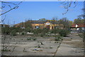
Former Jewsons Site
The site was at one time scheduled for redevelopment as a supermarket.
Image: © Paul Franks
Taken: 1 Apr 2012
0.11 miles
5
Chelmsford, country stores
Marriages Country Stores, off Parkway, next to Image Run by W&H Marriage & Sons Ltd, animal feed suppliers and former owners of Moulsham Mill. http://www.marriagefeeds.co.uk/
Image: © Mike Faherty
Taken: 15 May 2010
0.13 miles
7
The Army and Navy
New development on the site of the Army and Navy pub.
Image: © Paul Franks
Taken: 1 Apr 2012
0.14 miles
8
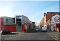
Baddow Road
Part of Baddow Road isolated by later road developments. The building on the left is the Salvation Army Citadel opened in 2009.
Image: © Paul Franks
Taken: 18 Feb 2013
0.15 miles
9
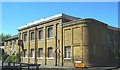
The First Wireless Factory in the World
The Hall Street works was the first wireless factory in the world. It was built for The Wireless Telegraph & Signal Co and was used for the production of the first wireless receiving and transmitting apparatus. the factory was later named The Marconi Wireless Telegraph Company. The Building is currently up for sale.
Image: © Ken Brown
Taken: 3 Jun 2011
0.15 miles
10
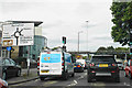
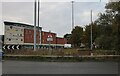
Queuing to get on the Army & Navy Roundabout
This approach is from Van Diemans Road, part of the A1114.
Image: © Bill Boaden
Taken: 2 Sep 2019
0.16 miles