IMAGES TAKEN NEAR TO
Goldlay Road, CHELMSFORD, CM2 0EL
Introduction
This page details the photographs taken nearby to Goldlay Road, CM2 0EL by members of the Geograph project.
The Geograph project started in 2005 with the aim of publishing, organising and preserving representative images for every square kilometre of Great Britain, Ireland and the Isle of Man.

There are currently over 7.5m images from over14,400 individuals and you can help contribute to the project by visiting https://www.geograph.org.uk
Image Map
Images are licensed for reuse under creativecommons.org/licenses/by-sa/2.0
Notes
- Clicking on the map will re-center to the selected point.
- The higher the marker number, the further away the image location is from the centre of the postcode.
Image Listing (68 Images Found)
Images are licensed for reuse under creativecommons.org/licenses/by-sa/2.0
Image
Details
Distance
1
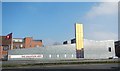
Salvation Army Citadel
Designed by Hudson Architects and opened in 2009, this building won the ACE/RIBA award for Religious Architecture. It replaced a 1970's building.
Image: © Paul Franks
Taken: 4 Mar 2013
0.03 miles
2
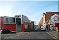
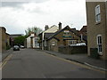
Baddow Road
Part of Baddow Road isolated by later road developments. The building on the left is the Salvation Army Citadel opened in 2009.
Image: © Paul Franks
Taken: 18 Feb 2013
0.05 miles
3
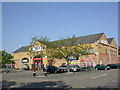
Chelmsford, superstore
Tesco Homeplus, on Parkway. http://www.tesco.com/storelocator/access/details.asp?bID=5389&l=C
Image: © Mike Faherty
Taken: 15 May 2010
0.08 miles
4
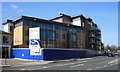
Affordable Housing
New development on the former site of a Volkswagen dealership, which has relocated to a former Marconi factory.
Image: © Paul Franks
Taken: 1 Apr 2012
0.10 miles
5
Chelmsford, The Woolpack
2010 Good Beer Guide-listed pub in Mildmay Road. Internally, central L-shaped bar, with drinking areas on three sides. Eight cask ales on offer at my visit, including one on gravity. For some customer comments, see http://www.beerintheevening.com/pubs/s/31/31927/Woolpack/Chelmsford
Image: © Mike Faherty
Taken: 15 May 2010
0.10 miles
6
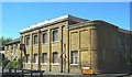
The First Wireless Factory in the World
The Hall Street works was the first wireless factory in the world. It was built for The Wireless Telegraph & Signal Co and was used for the production of the first wireless receiving and transmitting apparatus. the factory was later named The Marconi Wireless Telegraph Company. The Building is currently up for sale.
Image: © Ken Brown
Taken: 3 Jun 2011
0.11 miles
7
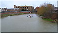
Part of the River in Chelmsford
A group of paddlers approach, paddling hard, as it appeared that they were taking part in a race, with race numbers attached to their kayaks.
Image: © Jeremy Bolwell
Taken: 10 Jan 2015
0.11 miles
8
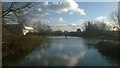
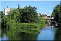
View down the River Chelmer
Looking downstream from the last bridge over the Chelmer before the River Can joins it from the right. Beyond the next bridge are floats warning of the weir, Chelmsford Gates; the navigable stretch of river begins below this. The white building on the left is Essex Record Office.
Image: © Christopher Hilton
Taken: 19 Jan 2018
0.11 miles
9
Chelmsford: the confluence of the Can and the Chelmer
The River Can is on the left. The Cathedral tower shows above the rooftops along the River Chelmer.
Image: © John Sutton
Taken: 22 Jun 2018
0.12 miles
10
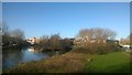
Confluence of the Rivers Can and Chelmer, Chelmsford
Image: © Christopher Hilton
Taken: 19 Jan 2018
0.12 miles