IMAGES TAKEN NEAR TO
Gilston Lane, HARLOW, CM20 2RF
Introduction
This page details the photographs taken nearby to Gilston Lane, CM20 2RF by members of the Geograph project.
The Geograph project started in 2005 with the aim of publishing, organising and preserving representative images for every square kilometre of Great Britain, Ireland and the Isle of Man.

There are currently over 7.5m images from over14,400 individuals and you can help contribute to the project by visiting https://www.geograph.org.uk
Image Map (Loading...)


Getting Data...Please wait
Leaflet Map data © OpenStreetMap
Images are licensed for reuse under creativecommons.org/licenses/by-sa/2.0
Notes
- Clicking on the map will re-center to the selected point.
- The higher the marker number, the further away the image location is from the centre of the postcode.
Image Listing (3 Images Found)
Images are licensed for reuse under creativecommons.org/licenses/by-sa/2.0
Image
Details
Distance
1

By Fiddlers Brook
Fiddler's Brook is to the left of this road which is nameless on the map.
Image: © Andrew Tatlow
Taken: 28 Jul 2006
0.18 miles
2
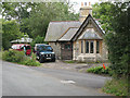
Cumberland Lodge
One of the lodges to Gilston Park.
Image: © Stephen Craven
Taken: 15 Aug 2009
0.20 miles
3
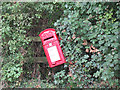
Tilted postbox
The Georgian postbox near Cumberland Lodge Image has been repainted in recent years but still leans precariously.
Image: © Stephen Craven
Taken: 15 Aug 2009
0.25 miles