IMAGES TAKEN NEAR TO
Rivermill, HARLOW, CM20 1NZ
Introduction
This page details the photographs taken nearby to Rivermill, CM20 1NZ by members of the Geograph project.
The Geograph project started in 2005 with the aim of publishing, organising and preserving representative images for every square kilometre of Great Britain, Ireland and the Isle of Man.

There are currently over 7.5m images from over14,400 individuals and you can help contribute to the project by visiting https://www.geograph.org.uk
Image Map
Images are licensed for reuse under creativecommons.org/licenses/by-sa/2.0
Notes
- Clicking on the map will re-center to the selected point.
- The higher the marker number, the further away the image location is from the centre of the postcode.
Image Listing (31 Images Found)
Images are licensed for reuse under creativecommons.org/licenses/by-sa/2.0
Image
Details
Distance
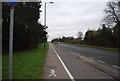
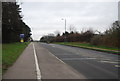
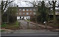
8
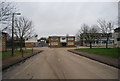
Harlow industrial area: Burnt Mill
Burnt Mill is a road lined with ligh industrial premises in the area along the northern edge of Harlow.
On the right, the distribution centre for Faber Music.
Image: © Christopher Hilton
Taken: 28 Mar 2023
0.14 miles
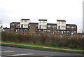
10
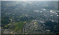
Harlow from the air
Housing around the roundabout on the site of Harlow FC's ground Image Harlow Town Park is in the left foreground.
Image: © Thomas Nugent
Taken: 16 Mar 2016
0.18 miles