IMAGES TAKEN NEAR TO
Nicholls Field, HARLOW, CM18 6ED
Introduction
This page details the photographs taken nearby to Nicholls Field, CM18 6ED by members of the Geograph project.
The Geograph project started in 2005 with the aim of publishing, organising and preserving representative images for every square kilometre of Great Britain, Ireland and the Isle of Man.

There are currently over 7.5m images from over14,400 individuals and you can help contribute to the project by visiting https://www.geograph.org.uk
Image Map (Loading...)


Getting Data...Please wait
Leaflet Map data © OpenStreetMap
Images are licensed for reuse under creativecommons.org/licenses/by-sa/2.0
Notes
- Clicking on the map will re-center to the selected point.
- The higher the marker number, the further away the image location is from the centre of the postcode.
Image Listing (10 Images Found)
Images are licensed for reuse under creativecommons.org/licenses/by-sa/2.0
Image
Details
Distance
1
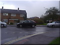
Tumbler Road on the corner of Purford Green
These are some of the original 1950s standard council housing in Harlow New Town
Image: © David Howard
Taken: 12 Apr 2012
0.08 miles
2
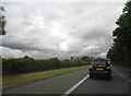
Second Avenue, Harlow
Latton Farm can just be seen on the left
Image: © David Howard
Taken: 13 Jun 2013
0.08 miles
4
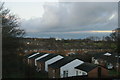
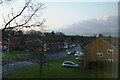
Harlow: looking north-east from Manor Hatch Close
Image: © Christopher Hilton
Taken: 18 Dec 2011
0.12 miles
5
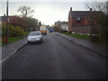
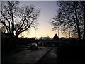
Harlow: Tumbler Road looking north, from an upstairs window on Manor Hatch Close
Image: © Christopher Hilton
Taken: 18 Dec 2011
0.16 miles
7
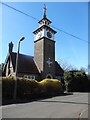
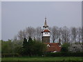
Clock Tower, Latton Street, Harlow
Situated in Latton Street CM20 3SD, this clock tower is near the Clock Tower Roundabout where the A414 and A1025 roads meet. It was built in 1864 by the Revd Joseph Arkwright in order to ensure the punctuality of his estate workers. Inscribed over the entrance is the text 'Work while it is day' which comes from the Gospel of St John ch9 v4. This clock tower is now a Grade II listed building.
Image: © David Hillas
Taken: 5 Apr 2018
0.18 miles
8
Harlow: the Co-op, Tumbler Road, on a winter evening
Approaching four and the light is fading, on a bitter afternoon not long before the shortest day.
Image: © Christopher Hilton
Taken: 18 Dec 2011
0.18 miles
9
The Clock Tower
The Clock Tower by the Clock Tower Roundabout.
Image: © Lynda Poulter
Taken: 12 Apr 2007
0.19 miles
10
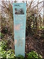
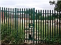
Blue Post in Latton Street
Situated in Latton Street, this post has the following wording:
HARLOW
see something different
Latton Street
The cycle track here is one of the original roads that threaded through the area, Latton Street. In common with many old country lanes in Harlow, the town's designers used them to allow cyclists and pedestrians to cross the town away from the noise and dirt of vehicle traffic, as if in the countryside.
The fields around are part of a 'green wedge'. These were included in the design of Harlow New Town to bring the countryside to the heart of the town and to separate the residential neighbourhoods. This wedge continues through to the town centre.
The Clock Tower along the lane was built by the Revd Joseph Arkwright in 1864 in order to ensure the punctuality of his estate workers. Inscribed over the entrance is the text 'Work while it is day'.
For more information visit
"www.harlowcivicsociety.org.uk"
"www.visitharlow.com"
Image: © David Hillas
Taken: 5 Apr 2018
0.25 miles