IMAGES TAKEN NEAR TO
Shoe Lane, HARLOW, CM17 9HU
Introduction
This page details the photographs taken nearby to Shoe Lane, CM17 9HU by members of the Geograph project.
The Geograph project started in 2005 with the aim of publishing, organising and preserving representative images for every square kilometre of Great Britain, Ireland and the Isle of Man.

There are currently over 7.5m images from over14,400 individuals and you can help contribute to the project by visiting https://www.geograph.org.uk
Image Map
Images are licensed for reuse under creativecommons.org/licenses/by-sa/2.0
Notes
- Clicking on the map will re-center to the selected point.
- The higher the marker number, the further away the image location is from the centre of the postcode.
Image Listing (18 Images Found)
Images are licensed for reuse under creativecommons.org/licenses/by-sa/2.0
Image
Details
Distance
1

Potters Cottage
It is difficult to put a date on this cottage at Foster Street, just outside Harlow but presumably it was once used by the village potter.
Image: © Marathon
Taken: 27 Jun 2015
0.13 miles
2
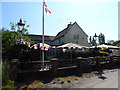
The Horns and Horseshoe pub, Foster Street
Still decked out with England flags the day after they got knocked out of the world cup when Costa Rica beat Italy.
Image: © Bikeboy
Taken: 21 Jun 2014
0.19 miles
3
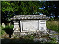
Tomb of Sarah Flower Adams in Foster Street Non-conformist Burial Ground
This burying ground was established in 1677 by William Woodward as a burying ground for the non-conformist congregation that he was the leader of in the Harlow area. Details are held of the approximately 640 people who have been buried here since 1812. Prior to that there are no records although a few gravestones date from the late 18th century.
The most famous tomb is the one here. It is to Sarah Flower Adams who composed the hymn 'Nearer My God To Thee'. She died in 1848 and is buried here with her parents and sister. The hymn is supposed to have been played by the ship's band as the Titanic was sinking.
Image: © Marathon
Taken: 27 Jun 2015
0.19 miles
4
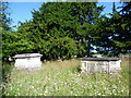
Foster Street Non-conformist Burial Ground
This burying ground was established in 1677 by William Woodward as a burying ground for the non-conformist congregation that he was the leader of in the Harlow area. Details are held of the approximately 640 people who have been buried here since 1812. Prior to that there are no records although a few gravestones date from the late 18th century.
The most famous tomb is the one on the left here. It is to Sarah Flower Adams who composed the hymn 'Nearer My God To Thee'. She died in 1848 and is buried here with her parents and sister. The hymn is supposed to have been played by the ship's band as the Titanic was sinking. For a close up of the tomb see http://www.geograph.org.uk/photo/4542813
Image: © Marathon
Taken: 27 Jun 2015
0.19 miles

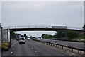
6
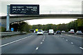
Variable Message Sign and Footbridge, M11 near to Foster Street
A variable message sign (VMS), also sometimes referred to as a matrix sign, is an electronic traffic sign used on motorways (and some other major routes) to give drivers information about special events and to warn them about traffic congestion, accidents, incidents, roadworks or speed limits on specific sections of the route. The signs may also suggest (or instruct) drivers to take alternative routes, limit speed, warn of duration and location of the incidents or just inform of the traffic conditions.
Image: © David Dixon
Taken: 28 Oct 2018
0.22 miles
7
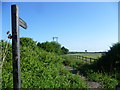
Footpath from Foster Street
The water tower in the distance is a well-known feature for anyone travelling along the M11. It is on the west side, just north of the Harlow turn off.
Image: © Marathon
Taken: 27 Jun 2015
0.23 miles