IMAGES TAKEN NEAR TO
Malkin Drive, HARLOW, CM17 9HL
Introduction
This page details the photographs taken nearby to Malkin Drive, CM17 9HL by members of the Geograph project.
The Geograph project started in 2005 with the aim of publishing, organising and preserving representative images for every square kilometre of Great Britain, Ireland and the Isle of Man.

There are currently over 7.5m images from over14,400 individuals and you can help contribute to the project by visiting https://www.geograph.org.uk
Image Map (Loading...)


Getting Data...Please wait
Leaflet Map data © OpenStreetMap
Images are licensed for reuse under creativecommons.org/licenses/by-sa/2.0
Notes
- Clicking on the map will re-center to the selected point.
- The higher the marker number, the further away the image location is from the centre of the postcode.
Image Listing (27 Images Found)
Images are licensed for reuse under creativecommons.org/licenses/by-sa/2.0
Image
Details
Distance


6
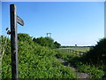
Footpath from Foster Street
The water tower in the distance is a well-known feature for anyone travelling along the M11. It is on the west side, just north of the Harlow turn off.
Image: © Marathon
Taken: 27 Jun 2015
0.17 miles