IMAGES TAKEN NEAR TO
Red Lion Crescent, HARLOW, CM17 9BN
Introduction
This page details the photographs taken nearby to Red Lion Crescent, CM17 9BN by members of the Geograph project.
The Geograph project started in 2005 with the aim of publishing, organising and preserving representative images for every square kilometre of Great Britain, Ireland and the Isle of Man.

There are currently over 7.5m images from over14,400 individuals and you can help contribute to the project by visiting https://www.geograph.org.uk
Image Map (Loading...)


Getting Data...Please wait
Leaflet Map data © OpenStreetMap
Images are licensed for reuse under creativecommons.org/licenses/by-sa/2.0
Notes
- Clicking on the map will re-center to the selected point.
- The higher the marker number, the further away the image location is from the centre of the postcode.
Image Listing (18 Images Found)
Images are licensed for reuse under creativecommons.org/licenses/by-sa/2.0
Image
Details
Distance
1
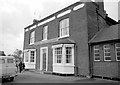
Play Area on Harlow Common
The houses are in Potters Field.
Image: © Glyn Baker
Taken: 26 May 2017
0.08 miles
2
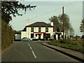
'The White Horse' public house
This is a view from Church Road and the pub stands on Potter Street
Image: © Robert Edwards
Taken: 24 Oct 2008
0.08 miles
3
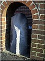
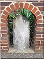
Old Milestone by Potter Street, Harlow
Carved stone post by the UC road, in parish of HARLOW (HARLOW District), Potter Street, set in archway in brick wall, on East side of road. Erected by the Woodford & Harlow turnpike trust in the 19th century.
Inscription reads:-
: (Epping) / 4 : : (Harlow) / 2 :
Essex HER listed. SMR Number: 15787
https://www.heritagegateway.org.uk/Gateway/Results_Single.aspx?uid=MEX1032869&resourceID=1001
Milestone Society National ID: EX_WFHW20.
Image: © JV Nicholls
Taken: Unknown
0.10 miles
4
Old Milepost
Old milepost near to Potter Street, Essex on what was the old A11. For overall view see http://www.geograph.org.uk/photo/3635083
Image: © Keith Evans
Taken: 3 Sep 2013
0.10 miles
5
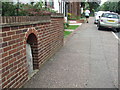
Old Milepost
Old milepost near to Potter Street, Essex on what was the old A11. For close up view see http://www.geograph.org.uk/photo/3635078
Image: © Keith Evans
Taken: 3 Sep 2013
0.11 miles
6
The White Horse, Potter Street
On the edge of Harlow Common.
Image: © Penny Mayes
Taken: 1 Jan 1971
0.12 miles
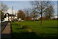
7
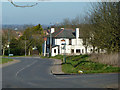
The White Horse, Potter Street, Harlow
A view down London Road from by the war memorial.
Image: © Robin Webster
Taken: 16 Mar 2014
0.12 miles
8
Church Road, Potter Street, Harlow
From outside the church of St Mary Magdalene, looking up the road to the White Horse pub. On the right the green space forms part of Harlow Common, which forms the southern edge of the New Town. The Forest Way path runs along this lane and across the Common.
Image: © Christopher Hilton
Taken: 12 Nov 2020
0.13 miles
9
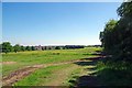
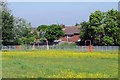
Harlow Common
Harlow Common http://www.wildessex.net/sites/Harlow%20Latton%20Commons.htm is managed by Harlow Council it is linked by an underpass to Image
Image: © Glyn Baker
Taken: 26 May 2017
0.13 miles