IMAGES TAKEN NEAR TO
Shaftesbury Road, EPPING, CM16 5BH
Introduction
This page details the photographs taken nearby to Shaftesbury Road, CM16 5BH by members of the Geograph project.
The Geograph project started in 2005 with the aim of publishing, organising and preserving representative images for every square kilometre of Great Britain, Ireland and the Isle of Man.

There are currently over 7.5m images from over14,400 individuals and you can help contribute to the project by visiting https://www.geograph.org.uk
Image Map
Images are licensed for reuse under creativecommons.org/licenses/by-sa/2.0
Notes
- Clicking on the map will re-center to the selected point.
- The higher the marker number, the further away the image location is from the centre of the postcode.
Image Listing (17 Images Found)
Images are licensed for reuse under creativecommons.org/licenses/by-sa/2.0
Image
Details
Distance
1
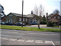
The United Reformed Church
The United Reformed Church is by the green in Lindsey Street. It used to be the Congregational Church. The building is also used by Local Government for voting on Election days.
Image: © Lynda Poulter
Taken: 19 Nov 2006
0.15 miles
2
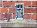
Ordnance Survey Flush Bracket S1435
This can be found on the roadside wall of a house in James Street.
For more detail see : http://www.bench-marks.org.uk/bm12098
Image: © Peter Wood
Taken: 23 Feb 2015
0.16 miles
3
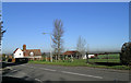
B181, Shaftesbury Farm on Lindsey St, Epping
Looking West along Lindsey St, Epping - Shaftesbury Farm . GPS: 45911/03113
Image: © Steven Muster
Taken: 19 Nov 2006
0.17 miles
4
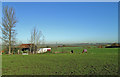
B181, Shaftesbury Farm on Lindsey St, Epping
Taken from Lindsey Road (B181), looking North at Shaftesbury Farm. GPS: 45911/03113
Image: © Steven Muster
Taken: 19 Nov 2006
0.17 miles
5
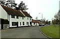
Old houses along Lindsey Street
This row of houses have a mixed history, with the oldest probably dating back to the 16th century.
Image: © Robert Edwards
Taken: 18 Apr 2008
0.18 miles
6
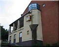
Epping Town Hall
This is a side view taken to show the council the deterioration being caused by cascading water
Image: © Jack Hill
Taken: 6 Mar 2005
0.19 miles
7
Lindsey Street
The original Lindsey Street dates back to about the year 1200. At one time it being the main road through Epping to Epping Upland. The road at the junction on the right is Maltings Lane which once housed the local brewery.
Image: © Lynda Poulter
Taken: 13 Apr 2007
0.19 miles
8
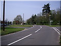
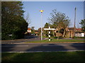
Road junction, Epping
A road junction with a traditional-style signpost, in Epping.
Image: © Malc McDonald
Taken: 3 Sep 2011
0.20 miles
9
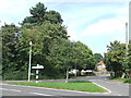
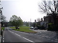
Road Junction
The road junction looking along Maltings Lane from Lindsey St.
Image: © Lynda Poulter
Taken: 15 Apr 2007
0.22 miles
10
Lindsey Street south west end
The south-west end of Lindsey Street, joining the High Street at the junction. Church Hill runs down the right of the picture.
Image: © Lynda Poulter
Taken: 13 Apr 2007
0.24 miles