IMAGES TAKEN NEAR TO
Hulletts Lane, BRENTWOOD, CM15 9RX
Introduction
This page details the photographs taken nearby to Hulletts Lane, CM15 9RX by members of the Geograph project.
The Geograph project started in 2005 with the aim of publishing, organising and preserving representative images for every square kilometre of Great Britain, Ireland and the Isle of Man.

There are currently over 7.5m images from over14,400 individuals and you can help contribute to the project by visiting https://www.geograph.org.uk
Image Map
Images are licensed for reuse under creativecommons.org/licenses/by-sa/2.0
Notes
- Clicking on the map will re-center to the selected point.
- The higher the marker number, the further away the image location is from the centre of the postcode.
Image Listing (20 Images Found)
Images are licensed for reuse under creativecommons.org/licenses/by-sa/2.0
Image
Details
Distance
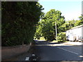
1
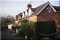
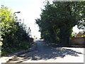
Hullets Lane
Although marked on the map as a byway open to all traffic Hullets Lane has a no motor vehicles restriction at the end of this terrace of cottages. However on the other side there is vehicular access to the A128.
Image: © Glyn Baker
Taken: 4 Mar 2013
0.02 miles
2
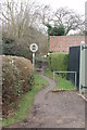
Hullets Lane - South end
The south end of Hullets Lane includes this short section of footpath about 100 m from the mini-roundabout at the junction with the Ongar Road.
Image: © Hugh Gorton
Taken: 12 Jan 2015
0.04 miles
3
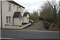
Hullets Lane - South end
At the south end of Hullets Lane the only vehicle access is down this short lane past these two cottages from the Ongar Road.
Image: © Hugh Gorton
Taken: 12 Jan 2015
0.06 miles
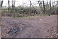
4
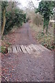
Bridge in Hullets Lane
Near the south end of Hullets Lane there is this bridge built from sleepers over a small stream.
Image: © Hugh Gorton
Taken: 12 Jan 2015
0.07 miles
5
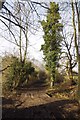
Bridge in Hullets lane
A bridge seemingly made of old railway sleepers in Hullets lane
Image: © Glyn Baker
Taken: 4 Mar 2013
0.08 miles
6
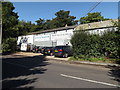
Business Premises off Coxtie Green Road
At the junction with Apple Gate
Image: © Geographer
Taken: 19 Sep 2015
0.10 miles
7
Coxtie Green Road, Pilgrims Hatch
Approaching the A128 Ongar Road at the junction with Apple Gate
Image: © Geographer
Taken: 19 Sep 2015
0.11 miles
8
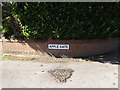
Apple Gate sign
On Apple Gate at the junction with Coxtie Green Road
Image: © Geographer
Taken: 19 Sep 2015
0.11 miles
9
Coxtie Green Road, Pilgrims Hatch
At the junction with Apple Gate
Image: © Geographer
Taken: 19 Sep 2015
0.11 miles
10
Hullets Lane
Junction of Hullets Lane (right) and the lane to Crow Green (left). Tyre tracks indicate vehicles turning into the lane to Crow Green.
Image: © Hugh Gorton
Taken: 12 Jan 2015
0.14 miles