IMAGES TAKEN NEAR TO
Thoby Lane, BRENTWOOD, CM15 0SY
Introduction
This page details the photographs taken nearby to Thoby Lane, CM15 0SY by members of the Geograph project.
The Geograph project started in 2005 with the aim of publishing, organising and preserving representative images for every square kilometre of Great Britain, Ireland and the Isle of Man.

There are currently over 7.5m images from over14,400 individuals and you can help contribute to the project by visiting https://www.geograph.org.uk
Image Map (Loading...)


Getting Data...Please wait
Leaflet Map data © OpenStreetMap
Images are licensed for reuse under creativecommons.org/licenses/by-sa/2.0
Notes
- Clicking on the map will re-center to the selected point.
- The higher the marker number, the further away the image location is from the centre of the postcode.
Image Listing (7 Images Found)
Images are licensed for reuse under creativecommons.org/licenses/by-sa/2.0
Image
Details
Distance
1
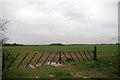
Fields Near Woodlands Farm
Clearly this farm has needed to invest to stop unwanted visitors driving on to their land.
Image: © Glyn Baker
Taken: 8 May 2015
0.02 miles
3
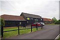
North Barn Near Woodlands Farm
Appropriately this is the base for a wood products manufacturer. There have been some changes in the past ten years see Image
Image: © Glyn Baker
Taken: 8 May 2015
0.03 miles
4
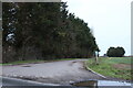
Farm track off Thoby Lane, Mountnessing
Image: © David Howard
Taken: 1 Jan 2023
0.04 miles
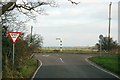
5
Thoby Lane, Mountnessing
At the junction of St Anne's Road
Image: © David Howard
Taken: 1 Jan 2023
0.09 miles
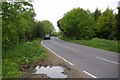
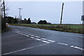
6
Road Junction on Thoby Lane
Thoby Lane runs left to right across the photo.
Image: © Trevor Harris
Taken: 29 Dec 2008
0.13 miles
7
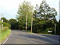
Thoby Lane at St. Annes Road junction
St. Anne is not the name of the local church, which is St. Giles at Mountnessing, so where did this name come from?
Image: © Robin Webster
Taken: 28 Jul 2012
0.15 miles