IMAGES TAKEN NEAR TO
Beehive Chase, BRENTWOOD, CM15 0PG
Introduction
This page details the photographs taken nearby to Beehive Chase, CM15 0PG by members of the Geograph project.
The Geograph project started in 2005 with the aim of publishing, organising and preserving representative images for every square kilometre of Great Britain, Ireland and the Isle of Man.

There are currently over 7.5m images from over14,400 individuals and you can help contribute to the project by visiting https://www.geograph.org.uk
Image Map
Images are licensed for reuse under creativecommons.org/licenses/by-sa/2.0
Notes
- Clicking on the map will re-center to the selected point.
- The higher the marker number, the further away the image location is from the centre of the postcode.
Image Listing (8 Images Found)
Images are licensed for reuse under creativecommons.org/licenses/by-sa/2.0
Image
Details
Distance
1
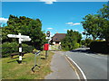
Watson's Corner, Wyatt's Green
This is the junction of Mill Lane out of shot (behind & left) Wyatt's Green Rd (ahead) and Church Lane (bearing right)
Image: © Glyn Baker
Taken: 8 May 2015
0.09 miles
2
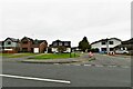
Wyatt's Green: Houses in Wyatt's Green Road
Image: © Michael Garlick
Taken: 17 Aug 2021
0.10 miles
3
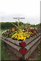
Flower Box at Watson's Corner
This road junction is brightened up by three flower tubs like this one
Image: © Glyn Baker
Taken: 8 May 2015
0.10 miles
4

Hook End, near Brentwood, Essex
Small hamlet about 5 miles north of Brentwood. Photo shows junction of Hook End Road and Hook End Lane.
Image: © John Winfield
Taken: 15 Aug 2005
0.14 miles
6
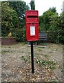
Elizabeth II postbox on Hay Green Lane
Postbox No. CM15 87.
Image: © JThomas
Taken: 24 Aug 2022
0.23 miles
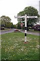
7
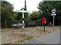
Fingerpost and Elizabeth II postbox on Hay Green Lane
Postbox No. CM15 87.
Image: © JThomas
Taken: 24 Aug 2022
0.23 miles
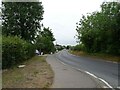
8
Hays Green Lane, Wyatt's Green
Hays Green Lane at Wyatt's Green in Essex.
Image: © Malc McDonald
Taken: 7 Jun 2015
0.23 miles