IMAGES TAKEN NEAR TO
Blackmore Road, BRENTWOOD, CM15 0HT
Introduction
This page details the photographs taken nearby to Blackmore Road, CM15 0HT by members of the Geograph project.
The Geograph project started in 2005 with the aim of publishing, organising and preserving representative images for every square kilometre of Great Britain, Ireland and the Isle of Man.

There are currently over 7.5m images from over14,400 individuals and you can help contribute to the project by visiting https://www.geograph.org.uk
Image Map (Loading...)


Getting Data...Please wait
Leaflet Map data © OpenStreetMap
Images are licensed for reuse under creativecommons.org/licenses/by-sa/2.0
Notes
- Clicking on the map will re-center to the selected point.
- The higher the marker number, the further away the image location is from the centre of the postcode.
Image Listing (10 Images Found)
Images are licensed for reuse under creativecommons.org/licenses/by-sa/2.0
Image
Details
Distance
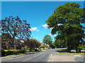
2
Blackmore Road, Hook End, near Doddinghurst
Blackmore Road at its junction with Hook End Road and Outings Lane, at Hook End in the Essex countryside. A traditional wooden signpost stands to the left of the image.
This image was taken on a chilly but very sunny January afternoon. Trees were bare, the sun was low in the sky and shadows were long.
Image: © Malc McDonald
Taken: 18 Jan 2020
0.02 miles
3
Blackmore Road, Hook End, near Doddinghurst
Image: © Malc McDonald
Taken: 7 Jun 2015
0.02 miles
4
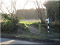
Pedestrian path at Hook End, near Doddinghurst
A pedestrian path alongside Blackmore Road at Hook End, in the Essex countryside.
This image was taken on a chilly but very sunny January afternoon. Trees were bare, the sun was low in the sky and shadows were long.
Image: © Malc McDonald
Taken: 18 Jan 2020
0.09 miles
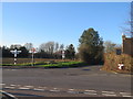
5
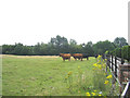
Grazing Cattle, Doddinghurst Place, Essex
Looking south from Blackmore Road. Doddinghurst Place is shown as a moated house, but unfortunately not visible from public access!
Image: © John Winfield
Taken: 15 Aug 2005
0.09 miles
6
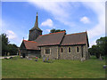
All Saints Church, Doddinghurst, Essex
The nave of the church dates back to 13th century whilst much of the rest was built two hundred years later. The church retains the oldest Marriage Register in England dating back to 1755.
Image: © John Winfield
Taken: 15 Aug 2005
0.09 miles
7
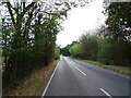
Blackmore Road near Meadow Farm
Towards Hook End.
Image: © JThomas
Taken: 24 Aug 2022
0.17 miles
8
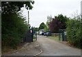
Entrance to Meadow Farm
Off Blackmore Road.
Image: © JThomas
Taken: 24 Aug 2022
0.20 miles
9
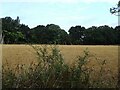
Stubble field near Meadow Farm
Off Blackmore Road.
Image: © JThomas
Taken: 24 Aug 2022
0.20 miles
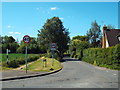
10
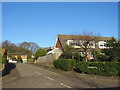
Spillbutters, Doddinghurst
Spillbutters is a residential cul-de-sac in the village of Doddinghurst, in Essex.
This image was taken on a chilly but very sunny January afternoon. Many of the trees were bare, the sun was low in the sky and shadows were long.
Image: © Malc McDonald
Taken: 18 Jan 2020
0.22 miles