IMAGES TAKEN NEAR TO
The Green, CHELMSFORD, CM1 4TY
Introduction
This page details the photographs taken nearby to The Green, CM1 4TY by members of the Geograph project.
The Geograph project started in 2005 with the aim of publishing, organising and preserving representative images for every square kilometre of Great Britain, Ireland and the Isle of Man.

There are currently over 7.5m images from over14,400 individuals and you can help contribute to the project by visiting https://www.geograph.org.uk
Image Map (Loading...)


Getting Data...Please wait
Leaflet Map data © OpenStreetMap
Images are licensed for reuse under creativecommons.org/licenses/by-sa/2.0
Notes
- Clicking on the map will re-center to the selected point.
- The higher the marker number, the further away the image location is from the centre of the postcode.
Image Listing (15 Images Found)
Images are licensed for reuse under creativecommons.org/licenses/by-sa/2.0
Image
Details
Distance
2
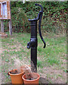
Remains of Water Pump, Chignall St James
Appears to have been made by Warners of London.
For wider view see Image
Image: © Roger Jones
Taken: 15 Aug 2018
0.03 miles
3
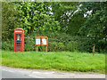
Phone box, notice board, pump, Chignall St James
Image: © Robin Webster
Taken: 28 Jul 2012
0.03 miles
4
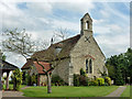
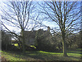
Former church, Chignall St. James
Now a house, although a public footpath still passes through the churchyard. When examining the churchyard about 30 years ago when the building was still a church, I came across the grave of Robert Miller Christy F.L.S. (1861-1928). This Victorian gentleman wrote in learned journals on an extraordinary range of subjects, from Essex Roman roads (a lot of speculation), to pin-eyed and thrum-eyed Primroses (a classic in botanical circles), to his hearing of gunfire in France from his house in Chignall St. James during the Great War.
Image: © Robin Webster
Taken: 28 Jul 2012
0.06 miles
5
Church conversion, Chignall St. James
The old parish church has been converted for residential use.
Image: © John Winfield
Taken: 9 Feb 2006
0.06 miles
6
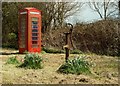
The village pump and telephone box at Chignall St. James
Image: © Robert Edwards
Taken: 14 Apr 2008
0.06 miles
7
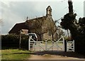
St. James; the parish church of Chignall St. James
Actually, it is no longer used as a church as it was recently converted into a residential home. Most of the church was restored and altered in the 19th century, but it probably started life as a small Norman church.
Image: © Robert Edwards
Taken: 14 Apr 2008
0.07 miles
9
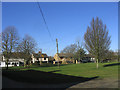
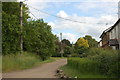
Village green, Chignall St. James
Looking west across the village green
Image: © John Winfield
Taken: 9 Feb 2006
0.08 miles
10
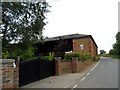
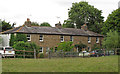
Converted barn at Stevens Farm
The plaque on the wall states "Erected July 1862 by William Crush, the former buildings having been destroyed by fire the 24 March of the same year". The smaller plaque underneath reads "Converted May 2001, new use, new life, The Door Ltd". See http://www.geograph.org.uk/photo/4610573 for a close up.
Image: © Bikeboy
Taken: 11 Aug 2015
0.16 miles