IMAGES TAKEN NEAR TO
Victoria Road, BRENTWOOD, CM14 5DR
Introduction
This page details the photographs taken nearby to Victoria Road, CM14 5DR by members of the Geograph project.
The Geograph project started in 2005 with the aim of publishing, organising and preserving representative images for every square kilometre of Great Britain, Ireland and the Isle of Man.

There are currently over 7.5m images from over14,400 individuals and you can help contribute to the project by visiting https://www.geograph.org.uk
Image Map (Loading...)


Getting Data...Please wait
Leaflet Map data © OpenStreetMap
Images are licensed for reuse under creativecommons.org/licenses/by-sa/2.0
Notes
- Clicking on the map will re-center to the selected point.
- The higher the marker number, the further away the image location is from the centre of the postcode.
Image Listing (48 Images Found)
Images are licensed for reuse under creativecommons.org/licenses/by-sa/2.0
Image
Details
Distance
1
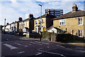
Houses on Crescent Road
Some comfortable looking old brick houses, with something more recent towering over the back.
Image: © Des Blenkinsopp
Taken: 28 Jun 2024
0.06 miles
2
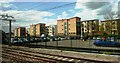
Car park and housing near Brentwood Station
Viewed from railway line.
Image: © Clint Mann
Taken: 3 May 2016
0.07 miles
3
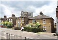
Crescent Road, Warley
Crescent Road was laid out in 1859 at the beginning of Brentwood's residential expansion south of the railway. These fine looking villas are conveniently located for the station.
Image: © Stephen McKay
Taken: 11 Jan 2023
0.07 miles
4
Crescent Road, Brentwood
A zebra crossing on Crescent Road, in the Essex town of Brentwood.
Image: © Malc McDonald
Taken: 28 Oct 2017
0.07 miles
5
Warley Hill near Brentwood station
The railway passes under the road at the bottom of the hill.
Image: © Robin Webster
Taken: 15 Sep 2011
0.08 miles
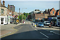
6
Warley Hill, Brentwood
Looking north towards the town centre.
Image: © Des Blenkinsopp
Taken: 28 Jun 2024
0.08 miles
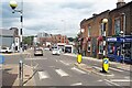
8
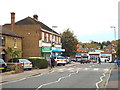
Shops on Warley Hill
Many commuter stations have a row of shops like this somewhere close by. In this case, near Brentwood station, there is small convenience store, a florist, a dry cleaners and an Indian takeaway - which fit the 'pick something up on the way home' category. All that is missing here is a taxi office.
Image: © Stephen McKay
Taken: 11 Jan 2023
0.09 miles
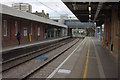
9
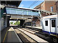
Brentwood station
Brentwood station was opened on 1st July 1840 as a temporary terminus by the Eastern Counties Railway (ECR) on what was to become the Great Eastern Main Line, until 1843, when the line was extended towards Colchester. The Great Eastern Railway (GER) took over in 1862 and renamed the station as Brentwood & Warley for Billericay in 1882, and shortened to Brentwood & Warley in 1889. Two additional tracks which are normally used by fast services were provided in 1934 by the London & North Eastern Railway.
Services are now operated by TFL Rail prior to the Elizabeth Line taking over in 2018. A TfL Rail train is about to set off back to Liverpool Street.
Image: © Marathon
Taken: 10 May 2017
0.09 miles
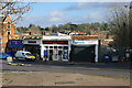
10
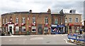
Pizza, Papers and Pub
Three neighbouring businesses on Warley Hill, Brentwood.
Image: © Des Blenkinsopp
Taken: 28 Jun 2024
0.09 miles