IMAGES TAKEN NEAR TO
De Paul Way, BRENTWOOD, CM14 4FT
Introduction
This page details the photographs taken nearby to De Paul Way, CM14 4FT by members of the Geograph project.
The Geograph project started in 2005 with the aim of publishing, organising and preserving representative images for every square kilometre of Great Britain, Ireland and the Isle of Man.

There are currently over 7.5m images from over14,400 individuals and you can help contribute to the project by visiting https://www.geograph.org.uk
Image Map
Images are licensed for reuse under creativecommons.org/licenses/by-sa/2.0
Notes
- Clicking on the map will re-center to the selected point.
- The higher the marker number, the further away the image location is from the centre of the postcode.
Image Listing (19 Images Found)
Images are licensed for reuse under creativecommons.org/licenses/by-sa/2.0
Image
Details
Distance
1
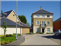
House on new development, Brentwood
A housing development on old hospital grounds.
Image: © Robin Webster
Taken: 26 May 2012
0.02 miles
2
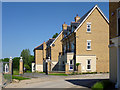
New houses, Brentwood
A housing development on old hospital grounds.
Image: © Robin Webster
Taken: 26 May 2012
0.03 miles
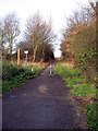
3
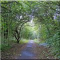
Footpath Crossing on Weald Road
The path opposite continues along Weald Road for a short distance before joining Green Lane beside the A12. Behind, the path has come from London Road.
Image: © Martin Addison
Taken: 12 Dec 2006
0.13 miles
4

The Path to Greenshaw
Green Lane is a handy connection for dog walkers etc. to get from Greenshaw and Costed Manor Way to St Faith’s Country Park. The right of way extends to the Ongar Road but it is now a suburban street.
Image: © Glyn Baker
Taken: 30 Jan 2010
0.14 miles
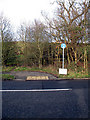
5
Green Lane
Bridleway leading to a housing estate and Ongar Road from Weald Road.
Image: © Martin Addison
Taken: 12 Dec 2006
0.14 miles
6

St Faith's Footbridge
A footbridge over a stream in St Faiths Country Park this has been managed by Brentwood Council since 1999 see http://www.brentwood.gov.uk/index.php?cid=617 for more info.
Image: © Glyn Baker
Taken: 30 Jan 2010
0.15 miles
7

View to Weald Rd
This is a view across St Faiths Country Park which has been managed by Brentwood Council since 1999 see http://www.brentwood.gov.uk/index.php?cid=617 for more info. You can see the new residential developments being built adjacent to Weald Road.
Image: © Glyn Baker
Taken: 30 Jan 2010
0.15 miles
8
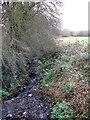
Stream and Farmland
A stream flowing out of Brentwood to join the River Ingrebourne runs beside a field. The line of trees in the distance mark the route of Honeypot Lane.
Image: © Martin Addison
Taken: 12 Dec 2006
0.15 miles
9

St Faith's Park
Formerly the grounds of a hospital since 1999 St Faiths has been a Country Park managed by Brentwood Council see http://www.brentwood.gov.uk/index.php?cid=617 for more info.
Image: © Glyn Baker
Taken: 30 Jan 2010
0.15 miles