IMAGES TAKEN NEAR TO
Burntwood, BRENTWOOD, CM14 4FJ
Introduction
This page details the photographs taken nearby to Burntwood, CM14 4FJ by members of the Geograph project.
The Geograph project started in 2005 with the aim of publishing, organising and preserving representative images for every square kilometre of Great Britain, Ireland and the Isle of Man.

There are currently over 7.5m images from over14,400 individuals and you can help contribute to the project by visiting https://www.geograph.org.uk
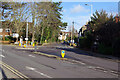
Image Map (Loading...)


Getting Data...Please wait
Leaflet Map data © OpenStreetMap
Images are licensed for reuse under creativecommons.org/licenses/by-sa/2.0
Notes
- Clicking on the map will re-center to the selected point.
- The higher the marker number, the further away the image location is from the centre of the postcode.
Image Listing (68 Images Found)
Images are licensed for reuse under creativecommons.org/licenses/by-sa/2.0
Image
Details
Distance
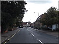
1
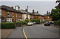
Westbury Road
Semi-detached houses near the junction with Kings Road.
Image: © Martin Addison
Taken: 9 Sep 2008
0.05 miles
2
Downsland Drive
Looking down the hill from Westbury Road. Westbury Drive is out of shot on the right.
Image: © Martin Addison
Taken: 9 Sep 2008
0.09 miles
3
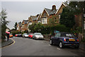
Westbury Road
Semi-detached housing. The road is popular with pedestrians and cars avoiding the junction of Kings Road and the High Street.
Image: © Martin Addison
Taken: 9 Sep 2008
0.09 miles
4
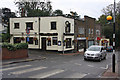
The Brewery Tap
Located on the corner of Kings Road and Primrose Hill, on the end of a small parade of shops.
Image: © Martin Addison
Taken: 9 Sep 2008
0.09 miles
5
B185 King's Road, Brentwood
At the junction with the B186 Queen's Road & B186 Warley Hill
Image: © Geographer
Taken: 19 Sep 2015
0.10 miles
6
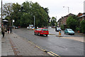
Kings Road, Queens Road
The roundabout at the junction with Queens Road, which can be seen in the centre of the photo. Kings Road continues up the hill on the left.
Image: © Martin Addison
Taken: 9 Sep 2008
0.11 miles
7
B186 Warley Hill, Brentwood
At the junction with the B185 King's Road & B186 Queen's Road
Image: © Geographer
Taken: 19 Sep 2015
0.12 miles
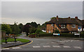
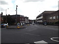
8
Roundabout at top of Warley Hill, Brentwood
Kings Road on the left, Queens Road on the right.
Image: © Robert Eva
Taken: 11 Sep 2017
0.12 miles
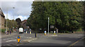
9
Queen's Road, Brentwood
Queen's Road is seen here running straight ahead from its junction with King's Road. Pedestrians might walk this way from the station to the town centre - it is quite a step.
Image: © Stephen McKay
Taken: 11 Jan 2023
0.12 miles
10
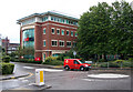
Chatham Way
A new cul-de-sac off Kings Road with office developments. The large building is the UK headquarters of Océ, a company supplying printers and similar items.
Image: © Martin Addison
Taken: 9 Sep 2008
0.13 miles