IMAGES TAKEN NEAR TO
William Hunter Way, BRENTWOOD, CM14 4EN
Introduction
This page details the photographs taken nearby to William Hunter Way, CM14 4EN by members of the Geograph project.
The Geograph project started in 2005 with the aim of publishing, organising and preserving representative images for every square kilometre of Great Britain, Ireland and the Isle of Man.

There are currently over 7.5m images from over14,400 individuals and you can help contribute to the project by visiting https://www.geograph.org.uk
Image Map (Loading...)


Getting Data...Please wait
Leaflet Map data © OpenStreetMap
Images are licensed for reuse under creativecommons.org/licenses/by-sa/2.0
Notes
- Clicking on the map will re-center to the selected point.
- The higher the marker number, the further away the image location is from the centre of the postcode.
Image Listing (115 Images Found)
Images are licensed for reuse under creativecommons.org/licenses/by-sa/2.0
Image
Details
Distance
2
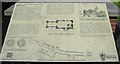
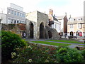
Chapel of St Thomas a Becket Information Board
This information board sits next to The Chapel of St Thomas a Becket at High Street, Brentwood.
Image: © Sean Davis
Taken: 7 Jul 2007
0.02 miles
3
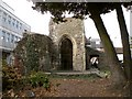
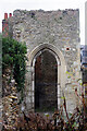
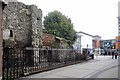
Ruins of St. Thomas a Becket chapel
These ruins stand along Brentwood's High Street, close to The Baytree Centre. The chapel dates back to the 13th century and all the remains now is part of the west and north wall of the nave and the lower half of the 14th century tower. The fabric of the tower shows some re-used Roman brick. The building remained in use as a chapel until 1835 and it was then used as a boys school until 1869 when it was mostly demolished.
Image: © Robert Edwards
Taken: 10 Oct 2009
0.02 miles
4
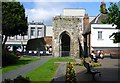
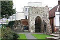
Chapel of St Thomas a Becket
The Chapel of St Thomas a Becket next to High Street, Brentwood. This is classified as a "Scheduled Monument", see https://historicengland.org.uk/listing/the-list/list-entry/1017452 and to read the information board next to it also see
Image: © Sean Davis
Taken: 7 Jul 2007
0.03 miles
5
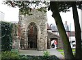
Chapel of St Thomas a Becket, Brentwood
The foundations of the Chapel of St Thomas a Becket, with its walls of irregular ragstone and flint, have been dated 1222 but may have been a re-dedication of an earlier building.
Image: © PAUL FARMER
Taken: 27 Oct 2015
0.03 miles
6
St Thomas à Becket Chapel, Brentwood
This ruin in the centre of Brentwood was built as a subsidiary chapel to South Weald Church in the 13th century and rebuilt in the mid to late 14th century. It ceased to be used as a chapel in 1835 and then served for a time as a boys' school before being mostly demolished in 1869. Today all that remain are the lower part of the tower and a small section of the nave. It is a scheduled ancient monument.
Image: © Stephen McKay
Taken: 11 Jan 2023
0.03 miles
10
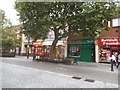
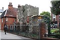
Baytree and Becket's Chapel
These are the ruins of a Chapel dedicated to the "turbulent priest" St Thomas Becket. The building was partly demolished in 1869. The current consolidation of the ruin dates to 1991.
Image: © Glyn Baker
Taken: 6 Mar 2013
0.03 miles