IMAGES TAKEN NEAR TO
Rollason Way, BRENTWOOD, CM14 4AY
Introduction
This page details the photographs taken nearby to Rollason Way, CM14 4AY by members of the Geograph project.
The Geograph project started in 2005 with the aim of publishing, organising and preserving representative images for every square kilometre of Great Britain, Ireland and the Isle of Man.

There are currently over 7.5m images from over14,400 individuals and you can help contribute to the project by visiting https://www.geograph.org.uk
Image Map (Loading...)


Getting Data...Please wait
Leaflet Map data © OpenStreetMap
Images are licensed for reuse under creativecommons.org/licenses/by-sa/2.0
Notes
- Clicking on the map will re-center to the selected point.
- The higher the marker number, the further away the image location is from the centre of the postcode.
Image Listing (49 Images Found)
Images are licensed for reuse under creativecommons.org/licenses/by-sa/2.0
Image
Details
Distance
1
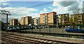
Car park and housing near Brentwood Station
Viewed from railway line.
Image: © Clint Mann
Taken: 3 May 2016
0.03 miles
2
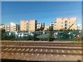
Flats on Rollason Way, Brentwood
The flats are seen from the railway, across the car park of Brentwood station.
Image: © Christopher Hilton
Taken: 26 Sep 2018
0.05 miles
3
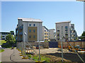
Flats, Rollason Way, Brentwood
Parts of this new development were still being finished at the time of this view.
Image: © Robin Webster
Taken: 26 May 2012
0.09 miles
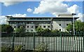
5
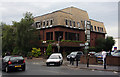
Highway House
Offices on the corner of Wharf Road and Kings Road, seen during the evening rush hour.
Image: © Martin Addison
Taken: 9 Sep 2008
0.13 miles
6
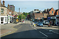
Warley Hill near Brentwood station
The railway passes under the road at the bottom of the hill.
Image: © Robin Webster
Taken: 15 Sep 2011
0.13 miles
7
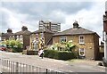
Houses on Crescent Road
Some comfortable looking old brick houses, with something more recent towering over the back.
Image: © Des Blenkinsopp
Taken: 28 Jun 2024
0.14 miles
9
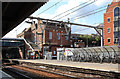
Brentwood Station
Brentwood station displays Transport for London's (TfL) Elizabeth Line roundel and services now operate right though the central section to Paddington. Brentwood is outside Greater London but transport networks do not neatly fit with political boundaries (and of course never have). The Elizabeth Line has taken TfL's rail operations into new areas, although in this case suburban services have been operated under the TfL Rail brand for some years. It is not entirely a new thing at Brentwood; at one time London Transport ran a Green Line bus service from central London out here.
Image: © Stephen McKay
Taken: 11 Jan 2023
0.14 miles
10
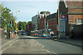
By Brentwood station
The road is Warley Hill, nearing the end of its not very steep descent.
Image: © Robin Webster
Taken: 15 Sep 2011
0.14 miles