IMAGES TAKEN NEAR TO
Warley Gap, BRENTWOOD, CM13 3DS
Introduction
This page details the photographs taken nearby to Warley Gap, CM13 3DS by members of the Geograph project.
The Geograph project started in 2005 with the aim of publishing, organising and preserving representative images for every square kilometre of Great Britain, Ireland and the Isle of Man.

There are currently over 7.5m images from over14,400 individuals and you can help contribute to the project by visiting https://www.geograph.org.uk
Image Map
Images are licensed for reuse under creativecommons.org/licenses/by-sa/2.0
Notes
- Clicking on the map will re-center to the selected point.
- The higher the marker number, the further away the image location is from the centre of the postcode.
Image Listing (15 Images Found)
Images are licensed for reuse under creativecommons.org/licenses/by-sa/2.0
Image
Details
Distance
1
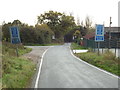
Bird Lane, Little Warley
Bird Lane at Little Warley, in Essex.
Image: © Malc McDonald
Taken: 28 Oct 2017
0.06 miles
2
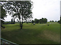
Warley Park Golf Course, Great Warley, Essex
Image: © John Winfield
Taken: 10 Jun 2005
0.08 miles
3
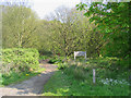
Footpath - Warley Gap
Warley Gap is a piece of strip woodland running adjacent to Bird Lane. The footpath runs north from here to Warley.
Image: © John Winfield
Taken: 4 May 2006
0.08 miles
4
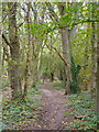
Path in Warley Gap
Warley Gap is a narrow belt of woodland, part of Thames Chase Community Forest. See http://www.thameschase.org.uk/visitor-centres/brentwood/warley-gap
Image: © Roger Jones
Taken: 18 Oct 2020
0.08 miles
5
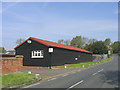
St Faith's Farm, Great Warley
The barn at St Faith's Farm on Bird Lane, Great Warley. On the route of the London Green Belt Way.
Image: © Sean Davis
Taken: 7 Jul 2007
0.09 miles
6
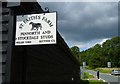
St. Faith's Farm, Great Warley
Situated on the west side of Bird Lane this farm is a horse stud for Pennworth, Stockdale and Welsh Cob horses/ponies.
Image: © John Winfield
Taken: 4 May 2006
0.10 miles
7
From Bird Lane looking West
Similar shot to Image but alternative composition, The sentiment remains the same.
Image: © Derek Voller
Taken: 29 Oct 2009
0.10 miles
8
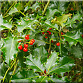
Holly in Warley Gap
Ilex aquifolium.
Warley Gap is a narrow belt of woodland, part of Thames Chase Community Forest. See http://www.thameschase.org.uk/visitor-centres/brentwood/warley-gap
Image: © Roger Jones
Taken: 18 Oct 2020
0.12 miles
9
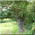
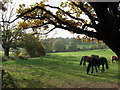
Fenced Path past Old Oak Tree
This on footpath 32 between St Faith's Farm at Bird Lane and
St. Mary the Virgin at Great Warley. It is on the route of the London Green Belt Way. The fence is there as there are usually horses in the field to the left.
Image: © Sean Davis
Taken: 7 Jul 2007
0.13 miles
10
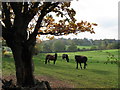
Northern end of Bird Lane, looking West.
Perfect autumn afternoon. Leaves turning, horses grazing, just a faint whiff of smoke on the breeze from the distant burning leaf pile. The English countryside at its best.
Image: © Derek Voller
Taken: 29 Oct 2009
0.14 miles