IMAGES TAKEN NEAR TO
Rowhedge, BRENTWOOD, CM13 2TS
Introduction
This page details the photographs taken nearby to Rowhedge, CM13 2TS by members of the Geograph project.
The Geograph project started in 2005 with the aim of publishing, organising and preserving representative images for every square kilometre of Great Britain, Ireland and the Isle of Man.

There are currently over 7.5m images from over14,400 individuals and you can help contribute to the project by visiting https://www.geograph.org.uk
Image Map
Images are licensed for reuse under creativecommons.org/licenses/by-sa/2.0
Notes
- Clicking on the map will re-center to the selected point.
- The higher the marker number, the further away the image location is from the centre of the postcode.
Image Listing (11 Images Found)
Images are licensed for reuse under creativecommons.org/licenses/by-sa/2.0
Image
Details
Distance
8
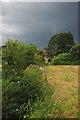
The End of Footpath 92
The footpath to Hanging Hill Lane runs alongside a ditch which had running water in it today
Image: © Glyn Baker
Taken: 6 Aug 2012
0.16 miles
9
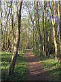
Path through Hare Hall Shaw Wood, Brentwood
Image: © Roger Jones
Taken: 31 Mar 2019
0.16 miles
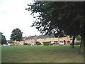
10
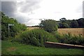
Footpath to Brentwood Road
This is the start of the footpath to the A128
Image: © Glyn Baker
Taken: 6 Aug 2012
0.19 miles