IMAGES TAKEN NEAR TO
Beeches Road, CHELMSFORD, CM1 2RX
Introduction
This page details the photographs taken nearby to Beeches Road, CM1 2RX by members of the Geograph project.
The Geograph project started in 2005 with the aim of publishing, organising and preserving representative images for every square kilometre of Great Britain, Ireland and the Isle of Man.

There are currently over 7.5m images from over14,400 individuals and you can help contribute to the project by visiting https://www.geograph.org.uk
Image Map (Loading...)


Getting Data...Please wait
Leaflet Map data © OpenStreetMap
Images are licensed for reuse under creativecommons.org/licenses/by-sa/2.0
Notes
- Clicking on the map will re-center to the selected point.
- The higher the marker number, the further away the image location is from the centre of the postcode.
Image Listing (19 Images Found)
Images are licensed for reuse under creativecommons.org/licenses/by-sa/2.0
Image
Details
Distance
1
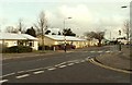
Some of the Prefabs in Beeches Road
Prefabs were built around the end of World War II as a quick and easy way of housing the homeless. This part of Chelmsford still has around 30 standing in good order.
Image: © Robert Edwards
Taken: 13 Jan 2009
0.12 miles
2
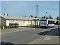
Hawksley BL8 prefabs, Beeches Road, Chelmsford
There are many along this side of the road, they were built in 1948-50 and are remarkable survivors of the great many prefabs built to various designs after WWII. This design has an aluminium skin and frame, which accounts suggest has proved very durable. The bus is on route 45A.
Image: © Robin Webster
Taken: 25 Mar 2012
0.13 miles
3
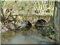
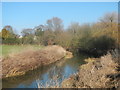
Bridge over former course of River Can
This acted as a bypass for the former Beach's Mill. It is now filled in behind the viewpoint, all the river goes over the modern weir at the mill site.
Image: © Robin Webster
Taken: 25 Mar 2012
0.18 miles
4
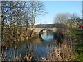
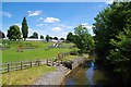
Bridge in Admiral's Park
The bridge crosses the River Can.
Image: © Paul Franks
Taken: 19 Feb 2013
0.19 miles
5
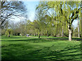
West Park, Chelmsford
The path follows the River Can, to the right.
Image: © Robin Webster
Taken: 25 Mar 2012
0.19 miles
7
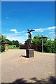
Bridge to Admiral's Park
The sculpture in the foreground is a decorative signpost.
Image: © Glyn Baker
Taken: 6 Jul 2016
0.20 miles
8
River Can in Admiral's Park
The marquees in the background are the Image
Image: © Glyn Baker
Taken: 6 Jul 2016
0.20 miles
9
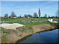
River Can bank work, Chelmsford, 2012
A start on anti-erosion work near the playground in Admirals Park.
Image: © Robin Webster
Taken: 25 Mar 2012
0.21 miles
10
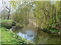
River Can, Chelmsford
Looking upstream, a major tributary of the Chelmer, and about the same size at the confluence just beyond the centre of town.
Image: © Robin Webster
Taken: 25 Mar 2012
0.21 miles