IMAGES TAKEN NEAR TO
Mountnessing Road, BILLERICAY, CM12 0TS
Introduction
This page details the photographs taken nearby to Mountnessing Road, CM12 0TS by members of the Geograph project.
The Geograph project started in 2005 with the aim of publishing, organising and preserving representative images for every square kilometre of Great Britain, Ireland and the Isle of Man.

There are currently over 7.5m images from over14,400 individuals and you can help contribute to the project by visiting https://www.geograph.org.uk
Image Map (Loading...)


Getting Data...Please wait
Leaflet Map data © OpenStreetMap
Images are licensed for reuse under creativecommons.org/licenses/by-sa/2.0
Notes
- Clicking on the map will re-center to the selected point.
- The higher the marker number, the further away the image location is from the centre of the postcode.
Image Listing (12 Images Found)
Images are licensed for reuse under creativecommons.org/licenses/by-sa/2.0
Image
Details
Distance
2
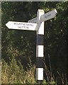
Old Direction Sign - Signpost by Mountnessing Road
No finial - 3 arms; by the UC road, in parish of Mountnessing (Brentwood District), East of Mountnessing Hall, junction of Mountnessing Road with Old Church Lane, on grass island.
To be surveyed
Milestone Society National ID: EX_TQ6596
Image: © Milestone Society
Taken: Unknown
0.06 miles
3
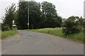
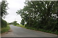
Country lanes junction near Billericay
The junction of Old Church Lane and Mountnessing Road, in Essex countryside near Billericay.
Image: © Malc McDonald
Taken: 7 Jun 2015
0.07 miles
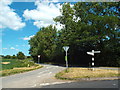
4
Junction of Old Church Road with Mountnessing Lane
Image: © Graham Loveland
Taken: 20 Jun 2009
0.08 miles
6
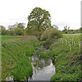
River Wid: Boundary between Mountnessing & Billericay
Image: © Roger Jones
Taken: 6 May 2019
0.15 miles
7
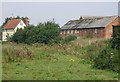
Lawness Barns
The farmhouse is many hundreds of years old and with several outbuildings sits alongside a water-meadow on the outskirts of Billericay. Drivers racing along the rat-run to the M25 will probably never even spot it through the trees.
Image: © Martin Tipper
Taken: 3 Sep 2005
0.19 miles
8
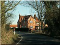
An old house on Mountnessing Lane
The house is known as Wardroper's.
Image: © Robert Edwards
Taken: 13 Feb 2008
0.22 miles
9
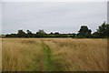
Footpath to Mountnessing Hall
This path links Little Crowbridge Grange and Mountnessing Hall
Image: © Glyn Baker
Taken: 1 Sep 2013
0.22 miles
10
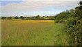
Meadow by path from Billericay to Mount Nessing church
Image: © Chris Morgan
Taken: 10 Jun 2015
0.22 miles