IMAGES TAKEN NEAR TO
Heath Road, BILLERICAY, CM11 1HR
Introduction
This page details the photographs taken nearby to Heath Road, CM11 1HR by members of the Geograph project.
The Geograph project started in 2005 with the aim of publishing, organising and preserving representative images for every square kilometre of Great Britain, Ireland and the Isle of Man.

There are currently over 7.5m images from over14,400 individuals and you can help contribute to the project by visiting https://www.geograph.org.uk
Image Map (Loading...)


Getting Data...Please wait
Leaflet Map data © OpenStreetMap
Images are licensed for reuse under creativecommons.org/licenses/by-sa/2.0
Notes
- Clicking on the map will re-center to the selected point.
- The higher the marker number, the further away the image location is from the centre of the postcode.
Image Listing (5 Images Found)
Images are licensed for reuse under creativecommons.org/licenses/by-sa/2.0
Image
Details
Distance
1
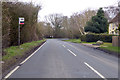
Hunt's Farm bus stop
On Heath Road, from Billericay towards Ramsden Heath.
Image: © Robin Webster
Taken: 25 Mar 2018
0.06 miles
2
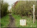
Public bridleway viewed from Heath Road
The bridleway continues on to Goatsmoor Lane.
Image: © Robert Edwards
Taken: 7 Apr 2008
0.09 miles
3
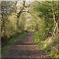
Bridleway to Ramsden Back Common, Ramsden Heath
Just south of: Image]
Image: © Roger Jones
Taken: 11 Apr 2015
0.10 miles
4
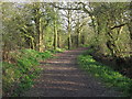
Bridleway to Ramsden Heath
From Ramsden Back Common.
Just north of: Image]
Image: © Roger Jones
Taken: 11 Apr 2015
0.12 miles
5
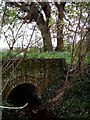
Bridle Path & Stream near Ramsden Back Common
The photo was taken looking west at the culvert that carries a stream under the bridle path linking Heath Road with Ramsden Back Common
Image: © Glyn Baker
Taken: 5 Nov 2005
0.15 miles