IMAGES TAKEN NEAR TO
Maldon Road, SOUTHMINSTER, CM0 7RN
Introduction
This page details the photographs taken nearby to Maldon Road, CM0 7RN by members of the Geograph project.
The Geograph project started in 2005 with the aim of publishing, organising and preserving representative images for every square kilometre of Great Britain, Ireland and the Isle of Man.

There are currently over 7.5m images from over14,400 individuals and you can help contribute to the project by visiting https://www.geograph.org.uk
Image Map
Images are licensed for reuse under creativecommons.org/licenses/by-sa/2.0
Notes
- Clicking on the map will re-center to the selected point.
- The higher the marker number, the further away the image location is from the centre of the postcode.
Image Listing (15 Images Found)
Images are licensed for reuse under creativecommons.org/licenses/by-sa/2.0
Image
Details
Distance
1
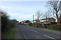
The Street, Steeple
Looking west along The Street from opposite the church.
Image: © Trevor Harris
Taken: 11 Jan 2015
0.12 miles
2
The green at Steeple beside Maldon Road
The chapel across the green has an inscribed plaque, above the door, with the date 1877. It is a grade II listed building known as a Peculiar People’s Chapel http://www.britishlistedbuildings.co.uk/en-428749-peculiar-people-s-chapel-steeple-essex
Image: © John Baker
Taken: 31 Mar 2014
0.15 miles
3
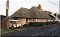
Thatched Cottage
Listed building: The Thatched Cottage. C17/C18 of possibly earlier origin, with later alterations and additions. See http://list.english-heritage.org.uk/resultsingle.aspx?uid=1237574 .
Note also Morris Minor Traveller in driveway.
Most of the items in this picture could have been taken in the last 50 years, the only item that dates this as a more recent picture is the yellow warning sign on the telegraph pole.
Image: © Roger Jones
Taken: 10 Dec 2011
0.15 miles
4
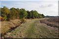
Footpath to Foxhall Farm
This path ends up at Image
Image: © Glyn Baker
Taken: 23 Oct 2016
0.16 miles
5
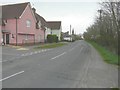
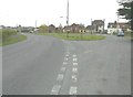
Looking east-northeast along The Street
In the distance is the steeple of St Lawrence and All Saints church, which is a grade II listed building dating from about 1884 that was built by reusing some materials from a demolished old church
http://www.britishlistedbuildings.co.uk/en-428921-church-of-st-lawrence-and-all-saints-ste
Image: © John Baker
Taken: 31 Mar 2014
0.17 miles
6
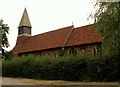
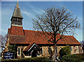
St. Laurence church, Steeple, Essex
This church was designed by the architect F. Chancellor and built in 1884. Material from the preceding medieval church was used in its construction.
Image: © Robert Edwards
Taken: 13 Jul 2006
0.18 miles
7
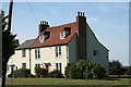
Steeple Hall
A 16th Century House and a 19th Century outshot dairy.
Image: © Lee Holmes
Taken: 9 Sep 2012
0.20 miles
8
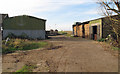
Hall Farm Yard
Also marked as Hill's Farm, Steeple Hall.
Public footpath runs past these farm buildings towards Mayland Creek.
Image: © Roger Jones
Taken: 10 Dec 2011
0.22 miles
9
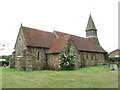
St Lawrence & All Saints, Steeple, Essex
Image: © Peter Stack
Taken: 13 Apr 2010
0.22 miles
10
St Lawrence & All Saints Church, Steeple, Essex
Image: © Colin Park
Taken: 2 Jun 2014
0.23 miles