IMAGES TAKEN NEAR TO
Goldsands Road, SOUTHMINSTER, CM0 7JP
Introduction
This page details the photographs taken nearby to Goldsands Road, CM0 7JP by members of the Geograph project.
The Geograph project started in 2005 with the aim of publishing, organising and preserving representative images for every square kilometre of Great Britain, Ireland and the Isle of Man.

There are currently over 7.5m images from over14,400 individuals and you can help contribute to the project by visiting https://www.geograph.org.uk
Image Map
Images are licensed for reuse under creativecommons.org/licenses/by-sa/2.0
Notes
- Clicking on the map will re-center to the selected point.
- The higher the marker number, the further away the image location is from the centre of the postcode.
Image Listing (37 Images Found)
Images are licensed for reuse under creativecommons.org/licenses/by-sa/2.0
Image
Details
Distance
2

Wibblers brewery
Southminster's micro-brewery and pub.
Image: © Robert Eva
Taken: 1 Feb 2018
0.04 miles
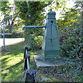
5
Detail of roadside pump, Southminster
Image: © Robin Webster
Taken: 22 Oct 2016
0.12 miles
6
Detail of roadside pump, Southminster
Image: © Robin Webster
Taken: 22 Oct 2016
0.12 miles
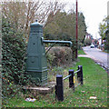
7
Roadside pump, Southminster
For a reverse view of this grade II listed pump, see Image For details of the inscriptions, see Image and Image
Image: © Robin Webster
Taken: 22 Oct 2016
0.12 miles
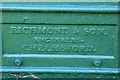
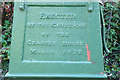
8
Water Pump
Village pump, with inscriptions: "Erected by The Governors of The Charter House, March 1832" and "Richmond and Son Engineers, Chelmsford"
Of importance as the only known identifiable casting of the Richmond Foundry and one of only 2 obelisk survivors, the other circa 1850 at Ridgewell:Essex and the Industrial Revolution. John Booker, E.R.O. 66. 1974.
Listed building see: http://list.english-heritage.org.uk/resultsingle.aspx?uid=1111795
Image: © Roger Jones
Taken: 6 Nov 2011
0.12 miles
9
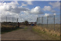
Gated path off Goldsands Road
Leading to disused, and now flooded, pits.
Image: © Robert Eva
Taken: 1 Feb 2018
0.14 miles
10
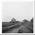
Southminster Station goods yard
July 1970 (exact day unknown). View south to the goods yard, in the distance is the gravel loading structures which were in use until 1979 (according to Wikipedia), to the right the goods shed and just to the right and behind of that, the nuclear flask facility. This was used last in August 2006 (again, info courtesy of Wikipedia)
Image: © Brian Whittle
Taken: 30 Sep 1970
0.15 miles