IMAGES TAKEN NEAR TO
Maldon Road, SOUTHMINSTER, CM0 7HT
Introduction
This page details the photographs taken nearby to Maldon Road, CM0 7HT by members of the Geograph project.
The Geograph project started in 2005 with the aim of publishing, organising and preserving representative images for every square kilometre of Great Britain, Ireland and the Isle of Man.

There are currently over 7.5m images from over14,400 individuals and you can help contribute to the project by visiting https://www.geograph.org.uk
Image Map
Images are licensed for reuse under creativecommons.org/licenses/by-sa/2.0
Notes
- Clicking on the map will re-center to the selected point.
- The higher the marker number, the further away the image location is from the centre of the postcode.
Image Listing (12 Images Found)
Images are licensed for reuse under creativecommons.org/licenses/by-sa/2.0
Image
Details
Distance
1

Bradwell on Sea: Where Mill End joins Maldon Road
Image: © Michael Garlick
Taken: 1 Nov 2022
0.08 miles
2
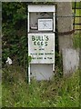
Bull's Eggs
Very tasty they are, too.
To be found by a field entrance where the B1021 meets the Latchingdon-Bradwell road: http://www.geograph.org.uk/photo/4993212
Image: © Stefan Czapski
Taken: 11 Jun 2016
0.09 miles

4

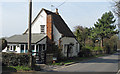
Weather-boarded cottage by the Maldon road
The Dengie peninsula is notable for the number of weather-boarded cottages which have survived - perhaps most especially at Tillingham.
This one stands near the point where the B1018 - from Maldon via Southminster and Tillingham - meets up with the rather more direct minor road which links Maldon to Bradwell by way of Mayland and Steeple. The eastward continuation of the minor road (to Bradwell) is designated B1018.
Image: © Stefan Czapski
Taken: 11 Jun 2016
0.10 miles
5
The Nook
This unusual small cottage on the B1021 Tillingham Road which runs between Tillingham and Bradwell on Sea, is a listed building.
Mid/late C17. Timber framed and rough rendered, List entry Number: 1337404 http://list.english-heritage.org.uk/resultsingle.aspx?uid=1337404
Image: © Roger Jones
Taken: 25 Mar 2012
0.16 miles
6
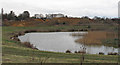
Gravel pits and lake
A disused pit has become a lake, whilst extraction continues behind.
Image: © Roger Jones
Taken: 18 Mar 2012
0.17 miles
7
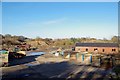
Gravel Workings at Mill End
I assume the Image exists as a result of these works.
Image: © Glyn Baker
Taken: 25 Nov 2016
0.17 miles
8
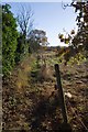
Footpath to Currys Farm
Judging by the amount of brambles I had to clear to get along this path it is not well used.
Image: © Glyn Baker
Taken: 25 Nov 2016
0.18 miles
9
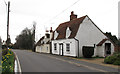
Mill End Cottage & Laburnum Cottage
Both cottages, on the B1021 Tillingham Road which runs between Tillingham and Bradwell on Sea, are listed buildings.
The nearest is Mill End Cottage, C18 or earlier. Timber framed and weatherboarded. List entry Number: 1110956 http://list.english-heritage.org.uk/resultsingle.aspx?uid=1110956.
The further is Laburnum Cottage, Cottage. C18 or earlier with later alterations. Timber framed and pebble dashed. List entry Number: 1308617 http://list.english-heritage.org.uk/resultsingle.aspx?uid=1308617
Image: © Roger Jones
Taken: 18 Mar 2012
0.20 miles
