IMAGES TAKEN NEAR TO
Willow Walk, SOUTHMINSTER, CM0 7FQ
Introduction
This page details the photographs taken nearby to Willow Walk, CM0 7FQ by members of the Geograph project.
The Geograph project started in 2005 with the aim of publishing, organising and preserving representative images for every square kilometre of Great Britain, Ireland and the Isle of Man.

There are currently over 7.5m images from over14,400 individuals and you can help contribute to the project by visiting https://www.geograph.org.uk
Image Map
Images are licensed for reuse under creativecommons.org/licenses/by-sa/2.0
Notes
- Clicking on the map will re-center to the selected point.
- The higher the marker number, the further away the image location is from the centre of the postcode.
Image Listing (7 Images Found)
Images are licensed for reuse under creativecommons.org/licenses/by-sa/2.0
Image
Details
Distance
1
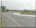
Development of Southminster West Business Park, Scotts Hill
The development of this site is described in Maldon District Council’s planning application 14/05016/DET as the “outline planning permission to erect detached, semi-detached and terraced dwellings and flats and associated garages, layout parking, amenity areas, estate roads, footpaths and landscaping” The applicant name is David Wilson Homes http://www.dwh.co.uk/# A huge area, beyond the roundabout, has been set aside for this development, bounded by Queen Street and Southfield Way. Due to the position of the sun, I felt this was the best shot I could achieve.
Image: © John Baker
Taken: 3 Apr 2014
0.11 miles
2
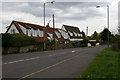
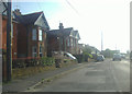
Southminster Rd
These cottages stand on the B1018 Southminster Rd on the edge of town.
Image: © Glyn Baker
Taken: 1 May 2006
0.13 miles
3
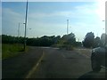
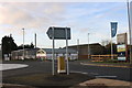
Roundabout on Scotts Hill, Southminster
Turning left takes you back into Southminster along the south side.
Image: © David Howard
Taken: 20 Jun 2012
0.13 miles
4
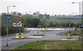
Double roundabout
Junction of B1018 (Southminster to Althorne) and B1021(Southminster to Burnham on Crouch).
The road nearest us to the right currently goes nowhere, no doubt marked for future development.
Image: © Roger Jones
Taken: 5 Nov 2011
0.14 miles
5
Roundabout on Scotts Hill, Southminster
A new housing development, Blackwater Reach, has just been built on the right next to the farm.
Image: © David Howard
Taken: 7 Dec 2019
0.15 miles
7
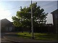
Devonshire Road at the junction of Queen Street
Image: © David Howard
Taken: 20 Jun 2012
0.22 miles