IMAGES TAKEN NEAR TO
Ceinfryn, HOLYWELL, CH8 9LD
Introduction
This page details the photographs taken nearby to Ceinfryn, CH8 9LD by members of the Geograph project.
The Geograph project started in 2005 with the aim of publishing, organising and preserving representative images for every square kilometre of Great Britain, Ireland and the Isle of Man.

There are currently over 7.5m images from over14,400 individuals and you can help contribute to the project by visiting https://www.geograph.org.uk
Image Map
Images are licensed for reuse under creativecommons.org/licenses/by-sa/2.0
Notes
- Clicking on the map will re-center to the selected point.
- The higher the marker number, the further away the image location is from the centre of the postcode.
Image Listing (14 Images Found)
Images are licensed for reuse under creativecommons.org/licenses/by-sa/2.0
Image
Details
Distance
1
Gwespyr Children's Play Area
Basketball hoop in what was once a small stone quarry
Image: © Gary Rogers
Taken: 11 Jan 2015
0.08 miles
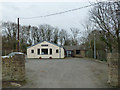
2

This was the home of Frank Nicholson...
A Welsh singer who was tragically killed by a stallion on Gwespyr Park in 1928
Image: © Gary Rogers
Taken: 11 Jan 2015
0.08 miles
4
Footpath from Gwespyr
With views on a good day of Point of Ayr, Liverpool Bay, the Dee Estuary and the Wirral
Image: © Maggie Cox
Taken: 29 Mar 2013
0.10 miles
5

WWII defences of North Wales: Gwespyr Royal Naval Radar Station (5)
Standby power generator building.
Image
Image: © Mike Searle
Taken: 31 Jul 2021
0.17 miles
6
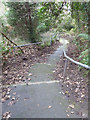
Very steep footpath
Linking Gwespyr to the A548
Image: © Gary Rogers
Taken: 11 Jan 2015
0.18 miles
7
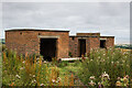
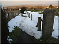
WWII defences of North Wales: Gwespyr Royal Naval Radar Station (2)
Two buildings, the one on the left housed the T273 naval CD transmitter/receiver equipment, and on the right, the radar plinth that contained turning gear for a rotating antenna on the roof within the circular brick parapet.
Image
Image: © Mike Searle
Taken: 31 Jul 2021
0.19 miles
8
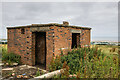
WWII defences of North Wales: Gwespyr Royal Naval Radar Station (4)
Radar plinth, the building that housed the turning gear for a roof mounted parabolic antenna.
Image
Image: © Mike Searle
Taken: 31 Jul 2021
0.19 miles
9
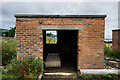
WWII defences of North Wales: Gwespyr Royal Naval Radar Station (3)
The Tx/Rx building.
Image
Image: © Mike Searle
Taken: 31 Jul 2021
0.20 miles
10
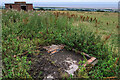
WWII defences of North Wales: Gwespyr Royal Naval Radar Station (1)
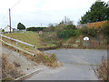
Overlooking the approaches to the mouths of the Dee and Mersey estuaries, the station was primarily used in a surface and coastal watching role, plotting ship movements, and keeping a close watch for enemy submarines. The station was one of only four other stations, all of which were in northern Scotland, and was only operational for a short time between December 1942 and October 1944. It was equipped with a type T273 Coastal Defence centimetric radar using a rotating parabolic dish antenna. Some of the buildings associated with the station still survive, albeit as ruins. The base of what was the guard picket post can be seen here in the foreground at the entrance to the site.
Image
Image: © Mike Searle
Taken: 31 Jul 2021
0.20 miles