IMAGES TAKEN NEAR TO
Rose Lane, MOLD, CH7 6WB
Introduction
This page details the photographs taken nearby to Rose Lane, CH7 6WB by members of the Geograph project.
The Geograph project started in 2005 with the aim of publishing, organising and preserving representative images for every square kilometre of Great Britain, Ireland and the Isle of Man.

There are currently over 7.5m images from over14,400 individuals and you can help contribute to the project by visiting https://www.geograph.org.uk
Image Map
Images are licensed for reuse under creativecommons.org/licenses/by-sa/2.0
Notes
- Clicking on the map will re-center to the selected point.
- The higher the marker number, the further away the image location is from the centre of the postcode.
Image Listing (7 Images Found)
Images are licensed for reuse under creativecommons.org/licenses/by-sa/2.0
Image
Details
Distance
1
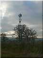
Telecommunications mast near Llong
The mast is on the hillside north of Llong.
Image: © Eirian Evans
Taken: 15 Feb 2008
0.13 miles
2

Mast north of Llong
Between Llong and Mynydd Isa.
Image: © Eirian Evans
Taken: 15 Feb 2008
0.13 miles
3
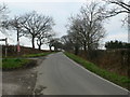
Rose Lane, Buckley
Just past its junction with Well Street. To the left is a bridleway to Llong.
Image: © Eirian Evans
Taken: 15 Feb 2008
0.14 miles
4
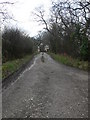
Bridleway to Llong
The start of a bridleway from Rose Lane, leading to a telecommunications mast and then onwards and downwards to Llong.
Image: © Eirian Evans
Taken: 15 Feb 2008
0.14 miles
5

Bridleway to Llong
Start of a steep descent to Llong
Image: © Eirian Evans
Taken: 15 Feb 2008
0.17 miles

7
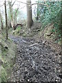
Muddy bridleway
The descent to Llong along this bridleway became extremely muddy, despite having no rain for at least 10 days. Muddy baptism for new boots.
Image: © Eirian Evans
Taken: 15 Feb 2008
0.23 miles