IMAGES TAKEN NEAR TO
Mold Road, MOLD, CH7 6LH
Introduction
This page details the photographs taken nearby to Mold Road, CH7 6LH by members of the Geograph project.
The Geograph project started in 2005 with the aim of publishing, organising and preserving representative images for every square kilometre of Great Britain, Ireland and the Isle of Man.

There are currently over 7.5m images from over14,400 individuals and you can help contribute to the project by visiting https://www.geograph.org.uk
Image Map
Images are licensed for reuse under creativecommons.org/licenses/by-sa/2.0
Notes
- Clicking on the map will re-center to the selected point.
- The higher the marker number, the further away the image location is from the centre of the postcode.
Image Listing (11 Images Found)
Images are licensed for reuse under creativecommons.org/licenses/by-sa/2.0
Image
Details
Distance
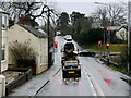
4
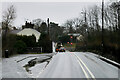
Alltami
Approaching the crossroads at the bottom of a steep hill at Alltami. This is the A494 Queensferry to Mold Road, and the road which crosses it goes left to Buckley and right to Northop. There is a pub, The Tavern, on the crossroads.
Image: © Eirian Evans
Taken: 7 Aug 2010
0.17 miles
7
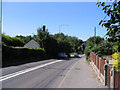
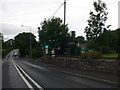
Traffic Lights at Alltami
As the comment on a neighbouring gridsquare says, this will be familiar to many people coming into the Mold area along the A494. Unusually, the lights are on green in this photo!
Image: © Peter Craine
Taken: 15 Jul 2006
0.18 miles
9
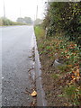
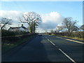
The A494 towards Alltami, and a milestone
Looking along the A494 towards Alltami with an old milestone half buried on the verge on the right. Old maps indicate that the milestone should be inscribed with 'Mold 2 Queensferry 4' but any inscription is below ground level. The Milestone Society reference for the stone is: FLT_MDQF02 Still visible on top of the milestone is an Ordnance Survey rivet bench mark which is shown on the 1874/84 map - Image
Image: © John S Turner
Taken: 11 Oct 2018
0.19 miles
10
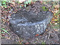
Milestone and rivet bench mark alongside the A494
This old milestone is nearly buried alongside the A494 between New Brighton and Alltami, Flintshire. Old maps indicate that it should be inscribed with 'Queensferry 4 Mold 2', although the inscription is below ground level now. The Milestone Society reference for the stone is: FLT_MDQF02 The Ordnance Survey rivet bench mark is recorded as far back as the 1874/84 map. See also Image
Image: © John S Turner
Taken: 11 Oct 2018
0.20 miles