IMAGES TAKEN NEAR TO
Chester Road, MOLD, CH7 6HH
Introduction
This page details the photographs taken nearby to Chester Road, CH7 6HH by members of the Geograph project.
The Geograph project started in 2005 with the aim of publishing, organising and preserving representative images for every square kilometre of Great Britain, Ireland and the Isle of Man.

There are currently over 7.5m images from over14,400 individuals and you can help contribute to the project by visiting https://www.geograph.org.uk
Image Map
Images are licensed for reuse under creativecommons.org/licenses/by-sa/2.0
Notes
- Clicking on the map will re-center to the selected point.
- The higher the marker number, the further away the image location is from the centre of the postcode.
Image Listing (13 Images Found)
Images are licensed for reuse under creativecommons.org/licenses/by-sa/2.0
Image
Details
Distance
2
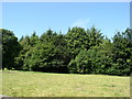
Wared Wood
Near Northop Hall, Flintshire
Image: © Eirian Evans
Taken: 17 Jul 2006
0.16 miles
3
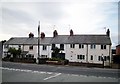
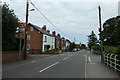
Terrace in Village Road, Northop Hall
This terrace, built in 1895 and known as 'Woodbine Cottages' is on the south side of Village Road in Northop Hall. In this picture the road is shown unusually devoid of cars.
Image: © Tim Stuart
Taken: 3 Sep 2008
0.18 miles
4
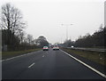
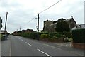
Northop Hall near Church Close
Looking along the main road through Northop Hall.
Image: © DS Pugh
Taken: 8 Aug 2020
0.18 miles
5
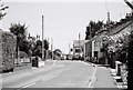
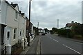
Northop Hall Village
The centre of Northop Hall village showing Village Road with the only remaining pub the 'Boars Head', universally known as the 'Top Monkey'.
Image: © Tim Stuart
Taken: 1 Jul 2014
0.21 miles
6
Church Close
Looking along Church Close in Northop Hall.
Image: © DS Pugh
Taken: 8 Aug 2020
0.21 miles
7
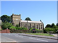
St Mary's church, Northop Hall
St Mary’s Church was opened in 1912.
Image: © Eirian Evans
Taken: 17 Jul 2006
0.22 miles
8
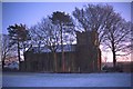
St Mary's Church, Northop Hall
A view of the church from the rear of the building, which shows the building in a rather different light from the street view.
Image: © Tim Stuart
Taken: Unknown
0.22 miles
9
St. Mary's Church
Looking towards St. Mary's Church in Northop Hall.
Image: © DS Pugh
Taken: 8 Aug 2020
0.22 miles
10
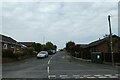
Northop Hall and Hero's Place
The road Hero's Place is on the right.
Image: © DS Pugh
Taken: 8 Aug 2020
0.22 miles