IMAGES TAKEN NEAR TO
Coed Du, MOLD, CH7 5HH
Introduction
This page details the photographs taken nearby to Coed Du, CH7 5HH by members of the Geograph project.
The Geograph project started in 2005 with the aim of publishing, organising and preserving representative images for every square kilometre of Great Britain, Ireland and the Isle of Man.

There are currently over 7.5m images from over14,400 individuals and you can help contribute to the project by visiting https://www.geograph.org.uk
Image Map
Images are licensed for reuse under creativecommons.org/licenses/by-sa/2.0
Notes
- Clicking on the map will re-center to the selected point.
- The higher the marker number, the further away the image location is from the centre of the postcode.
Image Listing (3 Images Found)
Images are licensed for reuse under creativecommons.org/licenses/by-sa/2.0
Image
Details
Distance
1
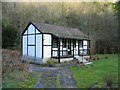
Cottage in Nant Alyn
Nant Alyn is named after the river Alun (Afon Alyn), which runs close to this cottage.
Image: © Peter Craine
Taken: 14 Jan 2007
0.14 miles
2
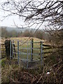
Kissing Gate
Footpath entrance leading to Nant Alyn valley, near Rhydymwyn.
Image: © J Scott
Taken: 17 Feb 2011
0.23 miles
3
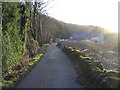
Road in Nant Alyn
In the distance, there is a caravan park following the river Alun/ Afon Alyn. The word 'Nant' means 'stream'.
Image: © Peter Craine
Taken: 14 Jan 2007
0.25 miles