IMAGES TAKEN NEAR TO
Bryn Rhosyn, MOLD, CH7 5EQ
Introduction
This page details the photographs taken nearby to Bryn Rhosyn, CH7 5EQ by members of the Geograph project.
The Geograph project started in 2005 with the aim of publishing, organising and preserving representative images for every square kilometre of Great Britain, Ireland and the Isle of Man.

There are currently over 7.5m images from over14,400 individuals and you can help contribute to the project by visiting https://www.geograph.org.uk
Image Map
Images are licensed for reuse under creativecommons.org/licenses/by-sa/2.0
Notes
- Clicking on the map will re-center to the selected point.
- The higher the marker number, the further away the image location is from the centre of the postcode.
Image Listing (17 Images Found)
Images are licensed for reuse under creativecommons.org/licenses/by-sa/2.0
Image
Details
Distance
1
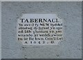
Plaque on Y Capel Tabernacl, Pantymwyn
This plaque indicates that the chapel was built in 1842.
"Now, my God, let, I beseech thee, thine eyes be open, and thine ears attentive unto the prayer that is made in this place."
"Second Book of Chronicles 6.40"
Thanks to Alan Fryer for the translation.
See also Image
Image: © John S Turner
Taken: 14 Jan 2007
0.11 miles
2
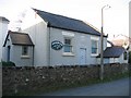
Y Capel Tabernacl, Pantymwyn
According to the plaque over the door, this Welsh Chapel was built in 1842. They now hold some services in English as well. See Image
Image: © John S Turner
Taken: 14 Jan 2007
0.11 miles
3
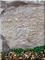
Bench mark in Pantymwyn, Flintshire
This Ordnance Survey bench mark is cut into the roadside face of a modernised old stone building on the corner of Cilcain Road and Pen y Fron Road - Image The mark was last recorded on the 1878 O.S. map.
Image: © John S Turner
Taken: 4 Dec 2018
0.12 miles
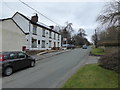
4
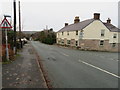
Cilcain Road and Pen y Fron Road junction, Pantymwyn
Looking across the junction of Pen y Fron Road and Cilcain Road in Pantymwyn. The restored building on the corner has an early Ordnance Survey cut bench mark on the Cilcain Road face - Image The bench mark was last recorded on the 1878 O.S. map.
Image: © John S Turner
Taken: 4 Dec 2018
0.12 miles
5
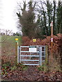
Public footpath across Mold Golf Course
This public footpath crosses Mold Golf Course south from Cilcain Road, to an unclassified road - Image Beware flying golf balls!
Image: © John S Turner
Taken: 4 Dec 2018
0.13 miles
9
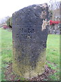
Milestone in Cilcain Road, Pantymwyn - West face
This milestone stands on the south side of Cilcain Road, Pantymwyn - Image This west face states 'Mold 3 Miles', and the east face 'Cilcen 1 Mile 3 1/2 Furlongs' - Image There is also a pivot bench mark on the top surface of the stone - Image
The milestone Society reference is: FLT_MDCI03
The bench mark database reference is: https://www.bench-marks.org.uk/bm69795
Image: © John S Turner
Taken: 4 Dec 2018
0.16 miles
10
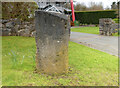
Old Milestone by Cilcain Road, Pantymwyn, Gwernaffield parish
Stone post by the UC road, in parish of Gwernaffield (Flintshire District), Cilcain Road; opposite Pantymwyn Post Office. NO185, on cut grass.
Inscription reads:-
: Cilcen 1 mile / 3½ Furlongs : : Mold / 3 Miles :
Carved bench mark and pivot on top.
Grade II listed.
Reference Number: 16131 https://cadwpublic-api.azurewebsites.net/reports/listedbuilding/FullReport?lang=&id=16131
Surveyed
Milestone Society National ID: FLT_MDCI03
Image: © Christopher Leather
Taken: 16 Mar 2024
0.16 miles