IMAGES TAKEN NEAR TO
Bryn Road, MOLD, CH7 5DG
Introduction
This page details the photographs taken nearby to Bryn Road, CH7 5DG by members of the Geograph project.
The Geograph project started in 2005 with the aim of publishing, organising and preserving representative images for every square kilometre of Great Britain, Ireland and the Isle of Man.

There are currently over 7.5m images from over14,400 individuals and you can help contribute to the project by visiting https://www.geograph.org.uk
Image Map
Images are licensed for reuse under creativecommons.org/licenses/by-sa/2.0
Notes
- Clicking on the map will re-center to the selected point.
- The higher the marker number, the further away the image location is from the centre of the postcode.
Image Listing (9 Images Found)
Images are licensed for reuse under creativecommons.org/licenses/by-sa/2.0
Image
Details
Distance
1
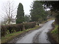
Ffordd Y Bryn
Farmhouse alongside Bryn Road near to junction with Church Lane.
Image: © J Scott
Taken: 17 Feb 2011
0.08 miles
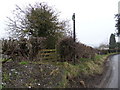
2

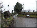
Ffordd Y Bryn
Footpath entrance at Bryn Road opposite junction with Church Lane.
Image: © J Scott
Taken: 17 Feb 2011
0.10 miles
4
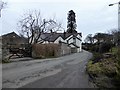
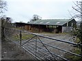
Bryn Bellan
Large country house on the outskirts of Gwernaffield, with bed and breakfast accommodation.
Image: © Eirian Evans
Taken: 9 Mar 2018
0.10 miles
5
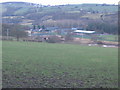
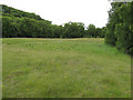
Alyn Valley
Looking slightly west of north over sheep grazing land from the junction of Church lane with a minor road along the southern slope of the Alyn Valley. The buildings in the distance are part of the Valley Works, Rhydymwyn and the modern Antelope Industrial Estate to the right. Compare this image with the black and white image at the start of the article here - www.subbrit.org.uk/rsg/sites/r/rhydymwyn/history.html
Image: © Phil Williams
Taken: 1 Jan 2006
0.12 miles
6
Bryn Road
Footpath entrance at Bryn Road junction with Church Lane, near Gwernaffield-y-Waun.
Image: © J Scott
Taken: 17 Feb 2011
0.13 miles
7
Rhydymwyn nature reserve
The site of the secret wartime facility has been kept free of interference for so long that it is now maintained as a nature reserve. The River Alyn used to meander across the site between the wooded slopes, but was taken into a culvert at the south-western edge and the floor of the valley levelled by taking the spoil from the creation of a series of huge underground storage levels. The suspicious contours remain from this time but grass has taken over the spoil.
Image: © Jonathan Wilkins
Taken: 11 Jun 2011
0.19 miles
9
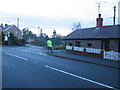
Tiny Cottages
The passing New Years Day jogger provides some scale highlighting the size of these tiny cottages at a junction on the road between Gwernaffield and Mold.
Image: © Phil Williams
Taken: 1 Jan 2006
0.25 miles