IMAGES TAKEN NEAR TO
Rhydtalog, MOLD, CH7 4NT
Introduction
This page details the photographs taken nearby to Rhydtalog, CH7 4NT by members of the Geograph project.
The Geograph project started in 2005 with the aim of publishing, organising and preserving representative images for every square kilometre of Great Britain, Ireland and the Isle of Man.

There are currently over 7.5m images from over14,400 individuals and you can help contribute to the project by visiting https://www.geograph.org.uk
Image Map
Images are licensed for reuse under creativecommons.org/licenses/by-sa/2.0
Notes
- Clicking on the map will re-center to the selected point.
- The higher the marker number, the further away the image location is from the centre of the postcode.
Image Listing (12 Images Found)
Images are licensed for reuse under creativecommons.org/licenses/by-sa/2.0
Image
Details
Distance
1
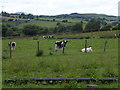
Young black and white cattle grazing
These are stirks (young males) so are probably a by product of a dairy farm, and would be fattening for beef.
Image: © John Haynes
Taken: 21 Jun 2016
0.05 miles
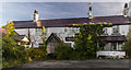
2
Liver Inn, Rhydtalog
Another pub gone west, the Liver Inn closed in 2007.
Image: © Eirian Evans
Taken: 10 Mar 2016
0.06 miles
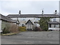
3
Liver Inn
The Liver Inn at Rhydtalog.
Image: © Peter McDermott
Taken: 11 Sep 2016
0.06 miles
6
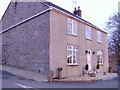
Travellers Farm, Rhydtalog.
OS flush bracket G2935 visible on the end wall.
Image: © Stephen Charles
Taken: 24 Jan 2005
0.10 miles
7
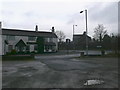
Liver Inn, Rhydtalog
On the junction of the A5104 and B5430.
Image: © Eirian Evans
Taken: 19 Jan 2008
0.10 miles
8
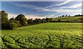
The Dingle
Fields and house at The Dingle.
Image: © Peter McDermott
Taken: 11 Sep 2016
0.15 miles
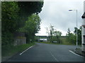
9
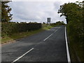
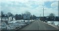
The B5430 approaching Rhydtalog from Graianrhyd
Image: © Eirian Evans
Taken: 27 Sep 2009
0.17 miles
10
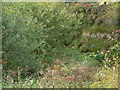
Terrig streamlet
One of the tributaries of the river Terrig in an overgrown little valley to the north-east of Rhydtalog.
Image: © Eirian Evans
Taken: 27 Sep 2009
0.19 miles