
IMAGES TAKEN NEAR TO
Padeswood Lake Road, MOLD, CH7 4HZ
Introduction
This page details the photographs taken nearby to Padeswood Lake Road, CH7 4HZ by members of the Geograph project.
The Geograph project started in 2005 with the aim of publishing, organising and preserving representative images for every square kilometre of Great Britain, Ireland and the Isle of Man.

There are currently over 7.5m images from over14,400 individuals and you can help contribute to the project by visiting https://www.geograph.org.uk
Image Map
Images are licensed for reuse under creativecommons.org/licenses/by-sa/2.0
Notes
- Clicking on the map will re-center to the selected point.
- The higher the marker number, the further away the image location is from the centre of the postcode.
Image Listing (5 Images Found)
Images are licensed for reuse under creativecommons.org/licenses/by-sa/2.0
Image
Details
Distance
1
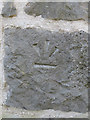
Inverted bench mark on Pen yr Allt barn, Padeswood
An inverted bench mark on Pen yr Allt converted barn, Padeswood. The barn is now a smart timber framed and stone house, and the inverted mark usually indicates that the stonework has been rebuilt.
Image: © John S Turner
Taken: 4 Jul 2019
0.09 miles
2
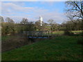
Footbridge over Black Brook
Padeswood cement factory on the horizon.
Image: © Eirian Evans
Taken: 15 Feb 2008
0.15 miles
4
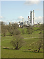
Valley of the Black Brook from Pen yr allt
The Padeswood Cement works dominates the landscape, particularly with the construction of the new shaft oven. This operates at high enough temperatures to enable old motor tyres to be burnt without emitting harmful residues.
Image: © Alan Murray-Rust
Taken: 14 Apr 2006
0.17 miles
5
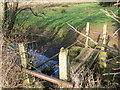
Need to take a running jump
This footbridge over Black Brook ends rather too abruptly, with a couple of yards' jump needed to complete the crossing
Image: © Eirian Evans
Taken: 15 Feb 2008
0.23 miles