IMAGES TAKEN NEAR TO
Ffordd Talwrn, MOLD, CH7 4BA
Introduction
This page details the photographs taken nearby to Ffordd Talwrn, CH7 4BA by members of the Geograph project.
The Geograph project started in 2005 with the aim of publishing, organising and preserving representative images for every square kilometre of Great Britain, Ireland and the Isle of Man.

There are currently over 7.5m images from over14,400 individuals and you can help contribute to the project by visiting https://www.geograph.org.uk
Image Map
Images are licensed for reuse under creativecommons.org/licenses/by-sa/2.0
Notes
- Clicking on the map will re-center to the selected point.
- The higher the marker number, the further away the image location is from the centre of the postcode.
Image Listing (9 Images Found)
Images are licensed for reuse under creativecommons.org/licenses/by-sa/2.0
Image
Details
Distance
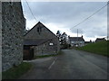
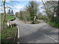
3
Pont Terrig, Afon Terrig and Ffordd y Pentre
Looking north along Ffordd y Pentre from Pont Terrig. Afon Terrig can be seen below, and there is an Ordnance Survey rivet bench mark on the parapet just in front of the camera - Image
Image: © John S Turner
Taken: 9 Apr 2014
0.21 miles
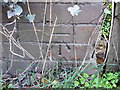
4
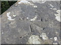
Rivet bench mark on Pont Terrig
This Ordnance Survey rivet bench mark is on the eastern parapet of Terrig Bridge, which carries Ffordd y Pentre over the Afon Terrig. The mark pre-dates the 1872 O.S. map. See also Image
Image: © John S Turner
Taken: 9 Apr 2014
0.22 miles
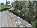
5
Pont Terrig and Ffordd y Pentre
Looking north towards Pont Terrig and Ffordd y Pentre from Ffordd Nercwys. The lane off to the right is Ffordd y Felin. The right-hand parapet of the bridge has an Ordnance Survey rivet bench mark - Image
Image: © John S Turner
Taken: 9 Apr 2014
0.22 miles
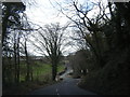
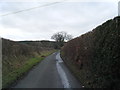
7
Ffordd y Pentre and the modern Pont Iago
Looking south along Ffordd y Pentre towards the modern Pont Iago. The ancient Pont Iago is out of sight to the right on private land, and this 'by-pass' and new bridge first appears on the 1962 O.S. map. There is an Ordnance Survey bench mark on the bridge parapet on the right nearest the camera - Image
Image: © John S Turner
Taken: 9 Apr 2014
0.22 miles
8
Bench mark on Pont Iago, Ffordd y Pentre
This Ordnance Survey bench mark is on the modern Pont Iago, which by-passes the nearby historic bridge. The Ordnance Survey database quotes the height for this mark, but the grid reference for the old bridge. See also Image and Image
Image: © John S Turner
Taken: 9 Apr 2014
0.22 miles
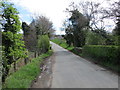
9

Ffordd y Pentre and a bench mark on Pont Iago
Looking north along Ffordd y Pentre from the modern Pont Iago. This section of the lane is a modern by-pass avoiding the narrow historic Pont Iago, which is further left/west. There is an Ordnance Survey bench mark on the bridge parapet on the left - Image
Image: © John S Turner
Taken: 9 Apr 2014
0.23 miles