IMAGES TAKEN NEAR TO
Spon Green, BUCKLEY, CH7 3BQ
Introduction
This page details the photographs taken nearby to Spon Green, CH7 3BQ by members of the Geograph project.
The Geograph project started in 2005 with the aim of publishing, organising and preserving representative images for every square kilometre of Great Britain, Ireland and the Isle of Man.

There are currently over 7.5m images from over14,400 individuals and you can help contribute to the project by visiting https://www.geograph.org.uk
Image Map
Images are licensed for reuse under creativecommons.org/licenses/by-sa/2.0
Notes
- Clicking on the map will re-center to the selected point.
- The higher the marker number, the further away the image location is from the centre of the postcode.
Image Listing (55 Images Found)
Images are licensed for reuse under creativecommons.org/licenses/by-sa/2.0
Image
Details
Distance
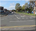
1
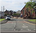
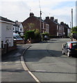
Spon Green, Buckley
Looking to the southwest from Brook Street along the road named Spon Green.
Bistre Methodist Chapel https://www.geograph.org.uk/photo/6296325 is on the corner of Brickfields.
Image: © Jaggery
Taken: 12 Oct 2019
0.03 miles
2
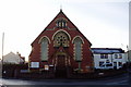
Bistre Methodist chapel, Buckley
On the corner of Brickfields and Spon Green.
Image: © Eirian Evans
Taken: 3 Dec 2008
0.04 miles
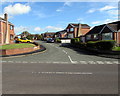
3
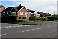
Bannel Lane bungalows, Buckley
The corner of Westbury Drive https://www.geograph.org.uk/photo/6295276 is on the left.
Image: © Jaggery
Taken: 12 Oct 2019
0.04 miles
4
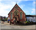
Bistre Methodist Chapel, Buckley
On the corner of Spon Green and Brickfields, Bistre Methodist Chapel
is part of the Buckley and Deeside Methodist Circuit.
Image: © Jaggery
Taken: 12 Oct 2019
0.04 miles
5
Bend in Spon Green, Buckley
In the southeast of Buckley, the road named Spon Green heads towards Meg's Lane.
Image: © Jaggery
Taken: 12 Oct 2019
0.05 miles
6
Westbury Drive, Buckley
Cul-de-sac on the northeast side of Brook Street.
Image: © Jaggery
Taken: 12 Oct 2019
0.06 miles
7

Conspicuous house, Brickfields, Buckley
On the north side of the cul-de-sac named Brickfields.
Image: © Jaggery
Taken: 12 Oct 2019
0.07 miles
8
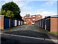
Electricity substation and flats behind two rows of lockup garages, Brickfields, Buckley
Set back from the north side of the cul-de-sac named Brickfields.
Image: © Jaggery
Taken: 12 Oct 2019
0.08 miles
9
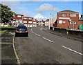
North along Brook Street, Buckley
Towards the A549 Chester Road. Buckley Workingmen's Club https://www.geograph.org.uk/photo/6296301 is on the right.
Image: © Jaggery
Taken: 12 Oct 2019
0.09 miles
10
Jubilee Road, Buckley
West along Jubilee Road from Brook Street.
Image: © Jaggery
Taken: 12 Oct 2019
0.10 miles