IMAGES TAKEN NEAR TO
Forest Walk, BUCKLEY, CH7 3AR
Introduction
This page details the photographs taken nearby to Forest Walk, CH7 3AR by members of the Geograph project.
The Geograph project started in 2005 with the aim of publishing, organising and preserving representative images for every square kilometre of Great Britain, Ireland and the Isle of Man.

There are currently over 7.5m images from over14,400 individuals and you can help contribute to the project by visiting https://www.geograph.org.uk
Image Map
Images are licensed for reuse under creativecommons.org/licenses/by-sa/2.0
Notes
- Clicking on the map will re-center to the selected point.
- The higher the marker number, the further away the image location is from the centre of the postcode.
Image Listing (66 Images Found)
Images are licensed for reuse under creativecommons.org/licenses/by-sa/2.0
Image
Details
Distance
1
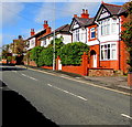
North side of Chester Road, Buckley
Houses and hedges alongside the A549 Chester Road on the westward ascent towards Buckley town centre.
Image: © Jaggery
Taken: 12 Oct 2019
0.10 miles
2
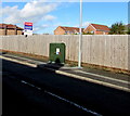
Dark green cabinet on the north side of Chester Road, Buckley
Telecoms cabinet alongside a wooden fence viewed in October 2019.
The fence has replaced railings seen in a July 2016 Google Street View.
Image: © Jaggery
Taken: 12 Oct 2019
0.10 miles
3
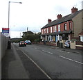
Row of five brick houses, Chester Road, Buckley
On the south side of the A549 Chester Road in the east of Buckley.
Image: © Jaggery
Taken: 12 Oct 2019
0.11 miles
4
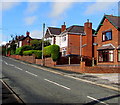
Houses and hedges on the north side of Chester Road, Buckley
Alongside the A549 Chester Road on the westward ascent towards Buckley town centre.
Image: © Jaggery
Taken: 12 Oct 2019
0.11 miles
5
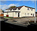
White housing on the north side of the A549 Chester Road, Buckley
A notice on a wall shows PRIVATE - NO PARKING.
Image: © Jaggery
Taken: 12 Oct 2019
0.11 miles
6

Buckley Town Trail
This part of the trail is north of the A549 Chester Road in the east of Buckley.
An English/Welsh trail direction sign https://www.geograph.org.uk/photo/6300626 is near the camera.
Image: © Jaggery
Taken: 12 Oct 2019
0.12 miles
7
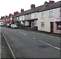
Chester Road houses, Buckley
Houses on the south side of the A549 Chester Road.
China Red takeaway https://www.geograph.org.uk/photo/6295280 on the right is on the corner of Brook Street.
Image: © Jaggery
Taken: 12 Oct 2019
0.12 miles
8
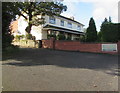
Willowdale Residential Care Home in Buckley
At 112 Chester Road on the south side of the A549.
Image: © Jaggery
Taken: 12 Oct 2019
0.12 miles
9
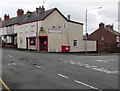
China Red in Buckley
Peking and Cantonese cuisine takeaway at 70 Chester Road on the corner of Brook Street.
Image: © Jaggery
Taken: 12 Oct 2019
0.13 miles
10

China Red name sign, Buckley
On the wall here. https://www.geograph.org.uk/photo/6295280
Image: © Jaggery
Taken: 12 Oct 2019
0.13 miles