IMAGES TAKEN NEAR TO
Milford Street, MOLD, CH7 1NW
Introduction
This page details the photographs taken nearby to Milford Street, CH7 1NW by members of the Geograph project.
The Geograph project started in 2005 with the aim of publishing, organising and preserving representative images for every square kilometre of Great Britain, Ireland and the Isle of Man.

There are currently over 7.5m images from over14,400 individuals and you can help contribute to the project by visiting https://www.geograph.org.uk
Image Map
Images are licensed for reuse under creativecommons.org/licenses/by-sa/2.0
Notes
- Clicking on the map will re-center to the selected point.
- The higher the marker number, the further away the image location is from the centre of the postcode.
Image Listing (145 Images Found)
Images are licensed for reuse under creativecommons.org/licenses/by-sa/2.0
Image
Details
Distance
1
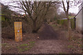
The Mold Railway Path
Part of the old railway route through Mold has been dedicated as a public footpath by Flintshire County Council. Access is available here from Milford Street. Although passenger services to Mold ended in 1962 the stretch here continued to be used by freight trains until 1983 and the track was not lifted until 1985. The footpath was formally opened in 2010 and, as the wooden board explains, was winner of the Bovril Great Outdoors Revival rambling category.
Image: © Stephen McKay
Taken: 12 Feb 2019
0.08 miles
2
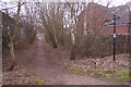
The Mold Railway Path
Part of the old railway route through Mold has been dedicated as a public footpath by Flintshire County Council. Access is available here from Milford Street. Although passenger services to Mold ended in 1962 the stretch here continued to be used by freight trains until 1983 and the track was not lifted until 1985.
Image: © Stephen McKay
Taken: 12 Feb 2019
0.09 miles
3
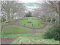
Steps leading up to the top of Mold Castle
Steps going up the motte. The castle was built c.1100 on a natural glacial mound.
Image: © Eirian Evans
Taken: 1 Apr 2011
0.11 miles
4
Gorsedd Stones on Bailey Hill
Erected for the 1923 National Eisteddfod in Mold.
Image: © Eirian Evans
Taken: 1 Apr 2011
0.12 miles
5
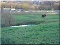
Horse field north of St Mary's church in Mold
Image: © Aaron Thomas
Taken: 2 Dec 2006
0.12 miles
6
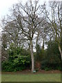
The Coronation Oak on Bailey Hill, Mold
"Well and truly" planted by Mrs Beresford, wife of a local JP, in 1902 to commemorate the coronation of King Edward VII.
Image: © Eirian Evans
Taken: 1 Apr 2011
0.12 miles
7
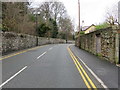
Denbigh Road, Mold, and a bench mark
Looking along Denbigh Road in front of Hermon house. There is an Ordnance Survey bench mark on the right between the driveway and the pink door - see Image
Image: © John S Turner
Taken: 13 Jan 2016
0.12 miles
8
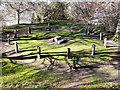
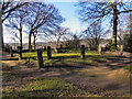
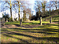
Gorsedd Circle, Bailey Hill
This Gosedd Circle was laid out in 1922, for the proclamation ceremony heralding the National Eisteddford visiting Mold in 1923. The circle is on a levelled area of Bailey Hill's outer ditch originally built as part of its defences in the twelfth century.
Gorsedd Stones (Welsh: Cerrig yr Orsedd) are groups of standing stones constructed for the National Eisteddfod of Wales. They form an integral part of the Druidic Gorsedd ceremonies of the Eisteddfod. Each stone structure is arranged in a circular formation typically consisting of twelve stone pillars, sometimes from the local area and sometimes, the stones have been brought in to represent the Welsh counties. A large, flat-topped stone, known as the Logan Stone.
http://news.bbc.co.uk/local/northeastwales/hi/people_and_places/nature/newsid_8659000/8659622.stm - BBC North east Wales
http://en.wikipedia.org/wiki/Gorsedd_stones - Wikipedia
Image: © David Dixon
Taken: 22 Mar 2011
0.12 miles
9
Bailey Hill Gorsedd Circle
This Gorsedd Circle was laid out in 1922, for the proclamation ceremony heralding the National Eisteddford visiting Mold in 1923. The circle is on a levelled area of Bailey Hill's outer ditch originally built as part of its defences in the twelfth century.
Gorsedd Stones (Welsh: Cerrig yr Orsedd) are groups of standing stones constructed for the National Eisteddfod of Wales. They form an integral part of the Druidic Gorsedd ceremonies of the Eisteddfod. Each stone structure is arranged in a circular formation typically consisting of twelve stone pillars, sometimes from the local area and sometimes, the stones have been brought in to represent the Welsh counties. A large, flat-topped stone, known as the Logan Stone.
http://news.bbc.co.uk/local/northeastwales/hi/people_and_places/nature/newsid_8659000/8659622.stm - BBC North east Wales
http://en.wikipedia.org/wiki/Gorsedd_stones - Wikipedia
Image: © David Dixon
Taken: 22 Mar 2011
0.12 miles
10
Gorsedd Circle, Bailey Hill
This Gorsedd Circle was laid out in 1922, for the proclamation ceremony heralding the National Eisteddford visiting Mold in 1923. The circle is on a levelled area of Bailey Hill's outer ditch originally built as part of its defences in the twelfth century.
Gorsedd Stones (Welsh: Cerrig yr Orsedd) are groups of standing stones constructed for the National Eisteddfod of Wales. They form an integral part of the Druidic Gorsedd ceremonies of the Eisteddfod. Each stone structure is arranged in a circular formation typically consisting of twelve stone pillars, sometimes from the local area and sometimes, the stones have been brought in to represent the Welsh counties. A large, flat-topped stone, known as the Logan Stone.
http://news.bbc.co.uk/local/northeastwales/hi/people_and_places/nature/newsid_8659000/8659622.stm - BBC North east Wales
http://en.wikipedia.org/wiki/Gorsedd_stones - Wikipedia
Image: © David Dixon
Taken: 22 Mar 2011
0.12 miles