IMAGES TAKEN NEAR TO
St. Davids Lane, MOLD, CH7 1LH
Introduction
This page details the photographs taken nearby to St. Davids Lane, CH7 1LH by members of the Geograph project.
The Geograph project started in 2005 with the aim of publishing, organising and preserving representative images for every square kilometre of Great Britain, Ireland and the Isle of Man.

There are currently over 7.5m images from over14,400 individuals and you can help contribute to the project by visiting https://www.geograph.org.uk
Image Map
Images are licensed for reuse under creativecommons.org/licenses/by-sa/2.0
Notes
- Clicking on the map will re-center to the selected point.
- The higher the marker number, the further away the image location is from the centre of the postcode.
Image Listing (35 Images Found)
Images are licensed for reuse under creativecommons.org/licenses/by-sa/2.0
Image
Details
Distance
1
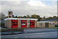
Mold fire station
Mold fire station, Melin Blwyn, Lead Mills, Mold, Flintshire, North Wales
Image: © Kevin Hale
Taken: 30 Oct 2007
0.10 miles
2
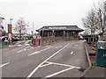
Mold's McDonald's
Drive-through cafe near Aldi in Mold
Image: © Eirian Evans
Taken: 10 Jan 2019
0.12 miles
3
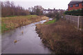
River Alyn, Leadmill
Looking downstream from Leadmill Bridge on the outskirts of Mold. The River Alyn is a tributary of the River Dee which it joins on the English border north-east of Wrexham.
Image: © Stephen McKay
Taken: 12 Feb 2019
0.12 miles
4
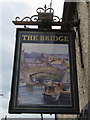
Sign for the former Bridge Inn, Mold
The sign for the old Bridge Inn, King Street, Mold, now awaiting redevelopment - Image
Image: © John S Turner
Taken: 31 May 2017
0.15 miles
5

The Bridge, Mold
This derelict pub on King Street presents a sad sight as closed down pubs always do. No obvious progress has been made since this view nearly two years earlier: Image The pub sign depicting a canal scene is a little fanciful - the bridge at Mold crosses an unnavigable river.
Image: © Stephen McKay
Taken: 12 Feb 2019
0.15 miles
6
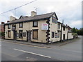
The former Bridge Inn, Mold
The old Bridge Inn stands on King Street/Heol-y-Brenin at its junction with Bro Alun. The inn has now closed and has planning consent for conversion to 'office and residential'. See also Image
Image: © John S Turner
Taken: 31 May 2017
0.16 miles
7
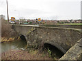
Leadmill Bridge over the River Alyn
The north west parapet of Leadmill Bridge seen from Bro Alun. The bridge carries the B5119 over the River Alyn.
Image: © John S Turner
Taken: 8 Jan 2014
0.16 miles
8
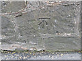
Bench mark on Leadmill Bridge, Mold
This bench mark is on the south east face of Leadmill Bridge. The bridge carries the A5119 over the River Alyn. See also: Image For details of the mark see: http://www.bench-marks.org.uk/bm53802
Image: © John S Turner
Taken: 8 Jan 2014
0.16 miles
9
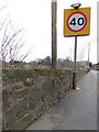
Stone wall alongside the B5119, and a bench mark
This stone wall alongside the B5119 is an extension of the parapet of Leadmill Bridge. There is an Ordnance Survey bench mark on the wall on the left. See: Image
Image: © John S Turner
Taken: 8 Jan 2014
0.17 miles
10
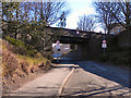
Love Lane, Mold
The bridge carrying King Street over Love Lane.
Image: © David Dixon
Taken: 22 Mar 2011
0.17 miles