IMAGES TAKEN NEAR TO
Victory Court, MOLD, CH7 1GL
Introduction
This page details the photographs taken nearby to Victory Court, CH7 1GL by members of the Geograph project.
The Geograph project started in 2005 with the aim of publishing, organising and preserving representative images for every square kilometre of Great Britain, Ireland and the Isle of Man.

There are currently over 7.5m images from over14,400 individuals and you can help contribute to the project by visiting https://www.geograph.org.uk
Image Map
Images are licensed for reuse under creativecommons.org/licenses/by-sa/2.0
Notes
- Clicking on the map will re-center to the selected point.
- The higher the marker number, the further away the image location is from the centre of the postcode.
Image Listing (23 Images Found)
Images are licensed for reuse under creativecommons.org/licenses/by-sa/2.0
Image
Details
Distance
1
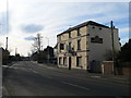
Tafarn Derwen, Mold
Another closed public house in Mold.
Image: © Eirian Evans
Taken: 24 Feb 2011
0.11 miles
2
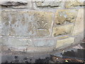
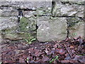
Bench mark by the entrance to Bromfield House
The entrance to Bromfield House drive seems to have been rebuilt so the bench mark may have been inverted and moved. However, it is still close to its recorded location.
Image: © John S Turner
Taken: 8 Jul 2014
0.12 miles
3
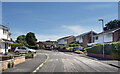
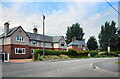
Avon Court, Mold
A short residential street on the south side of town.
Image: © Des Blenkinsopp
Taken: 15 Jun 2022
0.13 miles
4
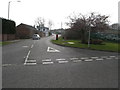
Bromfield Lane, Mold taken from Queens Lane
Image: © Maggie Cox
Taken: 14 Mar 2014
0.13 miles
5
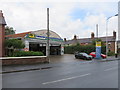
ATS Euromaster, Wrexham Road, Mold
A long standing tyre, and car and van related services business alongside Wrexham Road, Mold.
Image: © John S Turner
Taken: 8 Jul 2014
0.14 miles
7
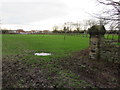
The south east corner of Mold cemetery and a playing field
Looking past the south east corner of Mold cemetery towards the playing field and the extended cemetery. There is an unrecorded Ordnance Survey bench mark on the wall on the right - see Image
Image: © John S Turner
Taken: 13 Jan 2016
0.15 miles
8
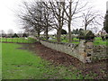
The south east side of Mold cemetery
Looking along the south east side of Mold cemetery. There is an unrecorded Ordnance Survey bench mark on the right of the corner post - see Image The nearest field is a playing field, and on the other side of the fence the cemetery has been extended.
Image: © John S Turner
Taken: 13 Jan 2016
0.16 miles
9
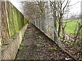
Footpath beside amenity land
From Mold Town Cemetery to Gas Lane
Image: © Maggie Cox
Taken: 14 Mar 2014
0.16 miles
10
Bench mark on Mold cemetery wall #2
This unrecorded bench mark is on the south east corner of Mold cemetery wall, just north of the corner - see also Image
Image: © John S Turner
Taken: 13 Jan 2016
0.17 miles