IMAGES TAKEN NEAR TO
Maes Alyn, CH7 1FY
Introduction
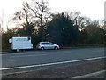
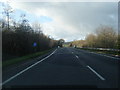
This page details the photographs taken nearby to Maes Alyn, CH7 1FY by members of the Geograph project.
The Geograph project started in 2005 with the aim of publishing, organising and preserving representative images for every square kilometre of Great Britain, Ireland and the Isle of Man.

There are currently over 7.5m images from over14,400 individuals and you can help contribute to the project by visiting https://www.geograph.org.uk
Image Map
Images are licensed for reuse under creativecommons.org/licenses/by-sa/2.0
Notes
- Clicking on the map will re-center to the selected point.
- The higher the marker number, the further away the image location is from the centre of the postcode.
Image Listing (3 Images Found)
Images are licensed for reuse under creativecommons.org/licenses/by-sa/2.0
Image
Details
Distance
2
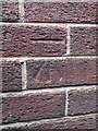
Bench mark on Mold Alun School
This Ordnance Survey bench mark is near the south east corner of the 1930s building, which is part of the more modern Mold Alun High School.
Image: © John S Turner
Taken: 30 Mar 2017
0.22 miles