IMAGES TAKEN NEAR TO
Shire View, MOLD, CH7 1DG
Introduction
This page details the photographs taken nearby to Shire View, CH7 1DG by members of the Geograph project.
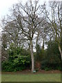
The Geograph project started in 2005 with the aim of publishing, organising and preserving representative images for every square kilometre of Great Britain, Ireland and the Isle of Man.

There are currently over 7.5m images from over14,400 individuals and you can help contribute to the project by visiting https://www.geograph.org.uk
Image Map
Images are licensed for reuse under creativecommons.org/licenses/by-sa/2.0
Notes
- Clicking on the map will re-center to the selected point.
- The higher the marker number, the further away the image location is from the centre of the postcode.
Image Listing (162 Images Found)
Images are licensed for reuse under creativecommons.org/licenses/by-sa/2.0
Image
Details
Distance
1
Steps leading up to the top of Mold Castle
Steps going up the motte. The castle was built c.1100 on a natural glacial mound.
Image: © Eirian Evans
Taken: 1 Apr 2011
0.06 miles
2
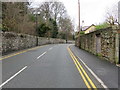
Denbigh Road, Mold, and a bench mark
Looking along Denbigh Road in front of Hermon house. There is an Ordnance Survey bench mark on the right between the driveway and the pink door - see Image
Image: © John S Turner
Taken: 13 Jan 2016
0.07 miles
3
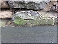
Bench mark alongside Denbigh Road near Hermon house
This bench mark is on the stone wall alongside Denbigh Road, just north of the driveway for Hermon house. See also Image
Image: © John S Turner
Taken: 13 Jan 2016
0.07 miles
4
The Coronation Oak on Bailey Hill, Mold
"Well and truly" planted by Mrs Beresford, wife of a local JP, in 1902 to commemorate the coronation of King Edward VII.
Image: © Eirian Evans
Taken: 1 Apr 2011
0.07 miles
5
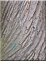
Close up of the bark of a tree near Mold Castle
Image: © Eirian Evans
Taken: 1 Apr 2011
0.08 miles
6
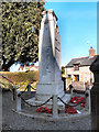
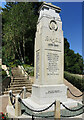
Mold Cenotaph
The Great War memorial in Mold is situated at 'the top of town' at the bottom of Bailey Hill. This view is from Bailey Hill, with the houses of High Street visible behind the monument.
Image: © David Dixon
Taken: 22 Mar 2011
0.08 miles
7
Mold Cenotaph
The Great War memorial in Mold is situated at 'the top of town' at the bottom of Bailey Hill. This view is from High Street, with Bailey Hill behind the monument.
Image: © David Dixon
Taken: 22 Mar 2011
0.08 miles
8
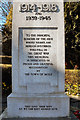
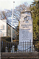
Mold War Memorial (detail)
The inscription on the south face of Image The names of those killed during the two World Wars are inscribed on the other three sides.
Image: © David Dixon
Taken: 22 Mar 2011
0.08 miles
9
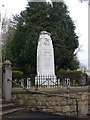
Mold War Memorial
At the bottom of Bailey Hill, near Pendref chapel.
Image: © Eirian Evans
Taken: 1 Apr 2011
0.08 miles