IMAGES TAKEN NEAR TO
High Street, BAGILLT, CH6 6HH
Introduction
This page details the photographs taken nearby to High Street, CH6 6HH by members of the Geograph project.
The Geograph project started in 2005 with the aim of publishing, organising and preserving representative images for every square kilometre of Great Britain, Ireland and the Isle of Man.

There are currently over 7.5m images from over14,400 individuals and you can help contribute to the project by visiting https://www.geograph.org.uk
Image Map (Loading...)


Getting Data...Please wait
Leaflet Map data © OpenStreetMap
Images are licensed for reuse under creativecommons.org/licenses/by-sa/2.0
Notes
- Clicking on the map will re-center to the selected point.
- The higher the marker number, the further away the image location is from the centre of the postcode.
Image Listing (38 Images Found)
Images are licensed for reuse under creativecommons.org/licenses/by-sa/2.0
Image
Details
Distance
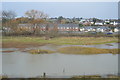
1
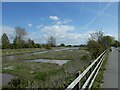
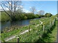
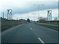
Wetland between railway and A548, Bagillt
Image: © David Smith
Taken: 23 Apr 2024
0.04 miles
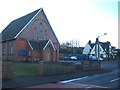
3
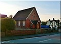
Former United Reformed Church on the High Street
Image: © Eirian Evans
Taken: 3 Feb 2012
0.05 miles
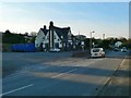
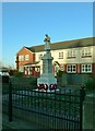
7
Bagillt United Reformed Church
A view looking west across what was once the A548 through Bagillt to the United Reformed Church and the Feathers public house beyond.
Image: © Phil Williams
Taken: 1 Jan 2006
0.09 miles