IMAGES TAKEN NEAR TO
Tyddyn Messham, BAGILLT, CH6 6DG
Introduction
This page details the photographs taken nearby to Tyddyn Messham, CH6 6DG by members of the Geograph project.
The Geograph project started in 2005 with the aim of publishing, organising and preserving representative images for every square kilometre of Great Britain, Ireland and the Isle of Man.

There are currently over 7.5m images from over14,400 individuals and you can help contribute to the project by visiting https://www.geograph.org.uk
Image Map (Loading...)


Getting Data...Please wait
Leaflet Map data © OpenStreetMap
Images are licensed for reuse under creativecommons.org/licenses/by-sa/2.0
Notes
- Clicking on the map will re-center to the selected point.
- The higher the marker number, the further away the image location is from the centre of the postcode.
Image Listing (7 Images Found)
Images are licensed for reuse under creativecommons.org/licenses/by-sa/2.0
Image
Details
Distance
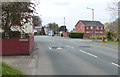
3
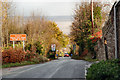
The "scenic" approach into Bagillt via Bryn Tirion
Image: © David J Smith
Taken: 5 Nov 2009
0.19 miles
5
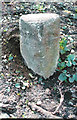
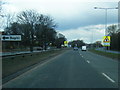
Old Milestone by the former A548, Holywell Street, Bagillt
By the UC road (was A548), Holywell Street, in parish of Bagillt (Flintshire District), Bagillt, at entrance to Whitefield Paddock/Cae Gwyn housing estate, South side of road.
Defaced Inscription once read:- : To / (HOLYWELL) / 4 : : To / (FLINT) / 1½
MILES :
Surveyed
Milestone Society National ID: FLT_FLHO01.
Image: © Milestone Society
Taken: Unknown
0.21 miles
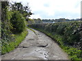
7
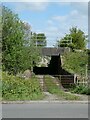
Railway bridge over track to The Marsh, Bagillt
Image: © David Smith
Taken: 23 Apr 2024
0.25 miles