IMAGES TAKEN NEAR TO
Reeces Terrace, High Street, BAGILLT, CH6 6AN
Introduction
This page details the photographs taken nearby to Reeces Terrace, High Street, CH6 6AN by members of the Geograph project.
The Geograph project started in 2005 with the aim of publishing, organising and preserving representative images for every square kilometre of Great Britain, Ireland and the Isle of Man.

There are currently over 7.5m images from over14,400 individuals and you can help contribute to the project by visiting https://www.geograph.org.uk
Image Map
Images are licensed for reuse under creativecommons.org/licenses/by-sa/2.0
Notes
- Clicking on the map will re-center to the selected point.
- The higher the marker number, the further away the image location is from the centre of the postcode.
Image Listing (71 Images Found)
Images are licensed for reuse under creativecommons.org/licenses/by-sa/2.0
Image
Details
Distance
1
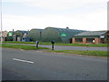
'Wright Garden Buildings Ltd'
Looking across the A548 dual carriageway at Bagillt towards the 'Wright Garden Buildings Ltd' site.
Image: © John S Turner
Taken: 1 Nov 2017
0.02 miles

3
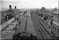
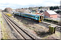
Bagillt Station
SE from A548 bridge towards Chester, with an Up stopping train at Up Slow line platform; four-track Chester - Holyhead main line. Note there are platforms only on the Slow lines; signalbox on right. Shotton Steelworks on horizon.
Image: © Ben Brooksbank
Taken: 7 Sep 1962
0.06 miles
4
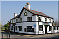
The Stag Inn, Bagillt
A public house situated between the High Street and the A548 in the centre of Bagillt, Flintshire, North Wales
Image: © clive dyke
Taken: 28 Mar 2011
0.07 miles
5
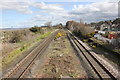
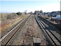
Site of Bagillt Railway Station
Looking south-east from the footbridge along the North Wales Coast Line where Bagillt railway station once stood. The station opened in 1849 and closed in 1966 as part of the Beeching Report economies.
Wikipedia https://en.wikipedia.org/wiki/Bagillt_railway_station
Image: © Jeff Buck
Taken: 5 Apr 2016
0.08 miles
6
Site of Bagillt Railway Station
Looking south-east from the footbridge along the North Wales Coast Line where Bagillt railway station once stood. The station opened in 1849 and closed in 1966 as part of the Beeching Report economies.
Wikipedia https://en.wikipedia.org/wiki/Bagillt_railway_station
Image: © Jeff Buck
Taken: 5 Apr 2016
0.08 miles
7
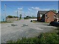
Road to the coastal marshes from A548, Bagillt
This leads to the Community Garden Image]
Image: © David Smith
Taken: 23 Apr 2024
0.08 miles
8
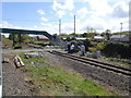
The former Bagillt railway station
I took this photo of the North Wales main line from the modern footbridge without realising that this is the site of old Bagillt station, long since demolished. By comparing it with Ben Brooksbank's photo Image it seems that I am looking through where the signal box used to be.
Image: © John S Turner
Taken: 7 Mar 2010
0.08 miles
9
View from a Chester-Holyhead train - site of Bagillt railway station
Opened in 1849 by the Chester & Holyhead Railway, later part of the London & North Western Railway, this station closed in 1966.
For more information, see http://www.disused-stations.org.uk/b/bagillt/index.shtml
Image: © Nigel Thompson
Taken: 2 May 2018
0.08 miles
10
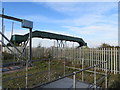
Footbridge over the North Wales railway line
Bagillt used to have a railway station near here, but that has long since disappeared.
Image: © John S Turner
Taken: 1 Nov 2017
0.09 miles