IMAGES TAKEN NEAR TO
Heath Lane, ELLESMERE PORT, CH66 7NS
Introduction
This page details the photographs taken nearby to Heath Lane, CH66 7NS by members of the Geograph project.
The Geograph project started in 2005 with the aim of publishing, organising and preserving representative images for every square kilometre of Great Britain, Ireland and the Isle of Man.

There are currently over 7.5m images from over14,400 individuals and you can help contribute to the project by visiting https://www.geograph.org.uk
Image Map
Images are licensed for reuse under creativecommons.org/licenses/by-sa/2.0
Notes
- Clicking on the map will re-center to the selected point.
- The higher the marker number, the further away the image location is from the centre of the postcode.
Image Listing (12 Images Found)
Images are licensed for reuse under creativecommons.org/licenses/by-sa/2.0
Image
Details
Distance
1
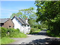
Heath Farm Cottages, Heath Lane
Heath Farm Cottages, just before the railway bridge on Heath Lane.
Image: © Sue Adair
Taken: 3 Jun 2006
0.02 miles
2
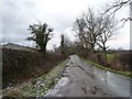
Heath Lane, west from a 27 metre spot height
Early afternoon, and the overnight snow has thawed to leave some dampness.
Image: © Christine Johnstone
Taken: 18 Jan 2015
0.02 miles
3
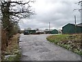
Entrance to Heath Lodge Nursery
Mid-January, not a very busy time of the year.
Image: © Christine Johnstone
Taken: 18 Jan 2015
0.02 miles
4
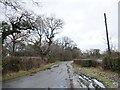
Heath Lane, north-east from a 27 metre spot height
A lot of sogginess in the verges, too much for just last night's snow.
Image: © Christine Johnstone
Taken: 18 Jan 2015
0.05 miles
5
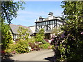
Brook Meadow Hotel and Restaurant, Childer Thornton
Situated on Heath Lane, Childer Thornton, Brook Meadow was built as a private residence for Major Bibby of the Bibby shipping line. In 1968 the house was leased to an order of Franciscan Monks before eventually becoming a hotel in 1983.
Image: © Sue Adair
Taken: 3 Jun 2006
0.08 miles
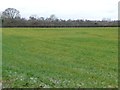
6
Woodland west of Brook Meadow Hotel
Looking east from the north side of Heath Lane.
Image: © Christine Johnstone
Taken: 18 Jan 2015
0.08 miles
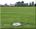
7
Hedge along Oakfield Road
Looking north-west from Heath Lane.
Image: © Christine Johnstone
Taken: 18 Jan 2015
0.09 miles
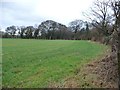
8
Farmland between Oakfield Road and Heath Lane
The distant row of houses are on Oakfield Road.
Image: © Christine Johnstone
Taken: 18 Jan 2015
0.09 miles
9
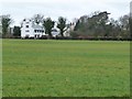
Large house off Oakfield Road, south-west of Hooton
This part of the Wirral is a mix of industrial sites and large secluded houses.
Image: © Christine Johnstone
Taken: 18 Jan 2015
0.15 miles
10
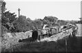
BR Standard 9F approaching Hooton on freight ? 1966
Unidentified under the grime that was a feature of locomotives towards the end of steam operation on British Railways. It is heading a typical general goods train on the line from Helsby to Hooton
Image: © Alan Murray-Rust
Taken: 20 Sep 1966
0.15 miles