IMAGES TAKEN NEAR TO
Hooton Road, ELLESMERE PORT, CH66 7NB
Introduction
This page details the photographs taken nearby to Hooton Road, CH66 7NB by members of the Geograph project.
The Geograph project started in 2005 with the aim of publishing, organising and preserving representative images for every square kilometre of Great Britain, Ireland and the Isle of Man.

There are currently over 7.5m images from over14,400 individuals and you can help contribute to the project by visiting https://www.geograph.org.uk
Image Map (Loading...)


Getting Data...Please wait
Leaflet Map data © OpenStreetMap
Images are licensed for reuse under creativecommons.org/licenses/by-sa/2.0
Notes
- Clicking on the map will re-center to the selected point.
- The higher the marker number, the further away the image location is from the centre of the postcode.
Image Listing (80 Images Found)
Images are licensed for reuse under creativecommons.org/licenses/by-sa/2.0
Image
Details
Distance
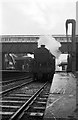
1
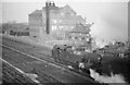
42537 leaving Hooton Station - 1966
The picture was taken of the locomotive, but is interesting in showing the whole of the former Tragasol works, which produced a variety of vegetable oils. Parts of the building survive in the 21st century, but not the main cross-wing seen here.
Image: © Alan Murray-Rust
Taken: 19 Nov 1966
0.05 miles
2
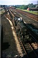
Stanier 8F at Hooton, 1966
Looking north from the road bridge at the station. Hooton was a staging point for freight operations, being the junction of the line from Ellesmere Port (Vauxhall Motors and Bowater) and Stanlow refinery with the Birkenhead to Chester line. Trains from the latter points had to reverse here to make their way south.
Image: © Alan Murray-Rust
Taken: 19 Sep 1966
0.06 miles
3
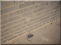
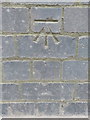
Cut Mark: Hooton Railway Station Bridge
OS Cut Mark on the railway bridge at Hooton Station. Number BM4006 on the Benchmark Database, see http://www.bench-marks.org.uk/bm28459
Image: © VBForever
Taken: 4 Mar 2011
0.07 miles
4
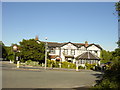
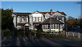
The Hooton Public House
The Hooton public house at the junction of Hooton Road with Waterworks Lane.
Image: © Sue Adair
Taken: 3 Jun 2006
0.07 miles
5
Bench mark on Hooton Road railway bridge
This bench mark is on the south face of the north side of the bridge. See also Image
Image: © John S Turner
Taken: 27 Feb 2016
0.08 miles
7
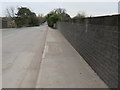
Hooton Road railway bridge
Looking west over Hooton Road railway bridge. There is an Ordnance Survey bench mark near the bottom right hand corner of the photo - Image
Image: © John S Turner
Taken: 27 Feb 2016
0.08 miles
8
'Crab' 2-6-0 at Hooton Station, 1961
The front of the locomotive is too grimy for the number to be decipherable.
This view shows the old footbridge and the main station buildings on the eastern platform. The left hand platform is no longer used by passenger services, and the nearer set of rails on which the loco is standing has been lifted with a set of buffer stops ending the track a bit beyond the footbridge https://www.geograph.org.uk/photo/4848137 .
Image: © Alan Murray-Rust
Taken: Unknown
0.08 miles
9
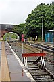
Siding and road bridge, Hooton Railway Station
Hooton Road bridge, with the unkempt diesel-only line from Birkenhead. The railway siding, at the platform, is an electrified stabling road, for Merseyrail passenger trains.
Image: © El Pollock
Taken: 8 Jun 2012
0.08 miles
10
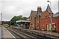
Disused platform, Hooton Railway Station
The disused platform, with the booking office. Hooton Road bridge is in the background. The booking office platform was in use, by local passenger trains, until electrification to Ellesmere Port was completed.
Image: © El Pollock
Taken: 8 Jun 2012
0.08 miles